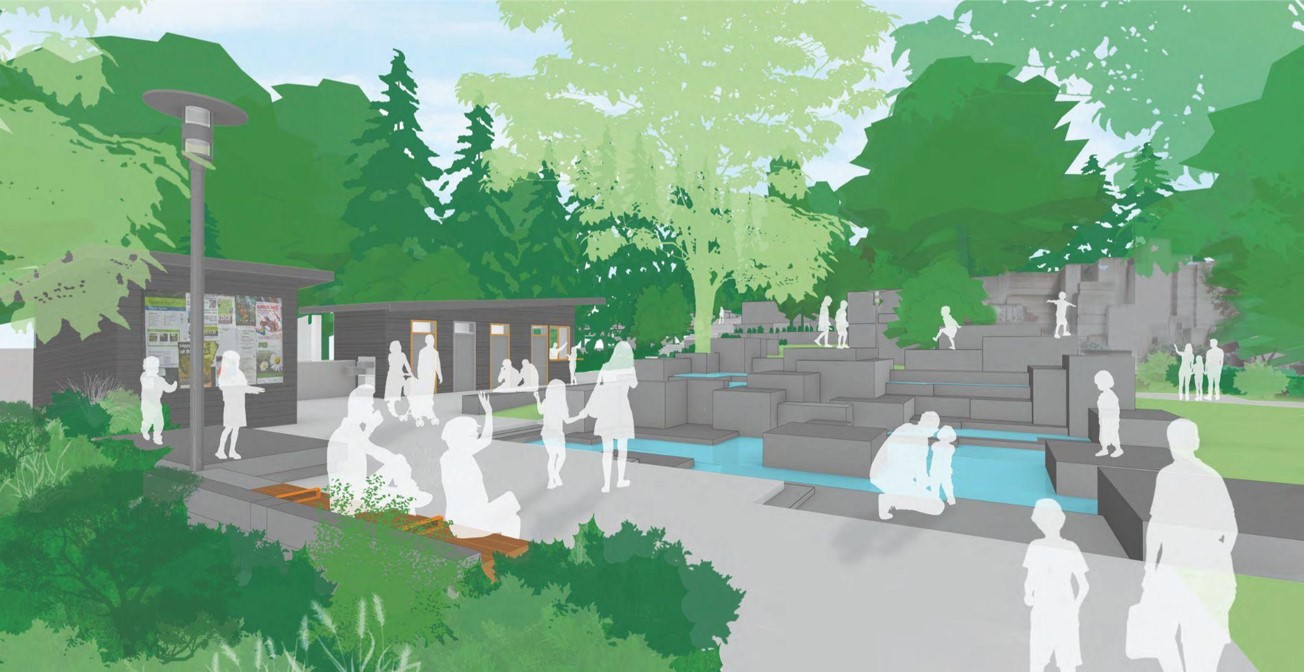
A conceptual pedestrian lane over I-5 between Pike Street and Pine Street, tying into the Pike-Pine commercial corridor and proximity to the busy Convention Center. Click to enlarge and see a before-and-after view. (Graphic by the author)
Amid Seattle’s rapidly growing inner neighborhoods remains the urban scar of Interstate 5, a massive concrete and steel ribbon that is the lasting legacy of 20th century transportation engineers. It helps move thousands of people and tons of freight every day through the biggest city in the Pacific Northwest, but it gives little to those who don’t drive and to people who live and work around it. The problems are obvious: noise, traffic, and poor urban design that makes people on the street feel isolated and wastes valuable urban land. The solution is equally clear but admittedly ambitious: lidding the freeway to mitigate its sights and sounds while simultaneously transforming the public realm of Downtown Seattle.
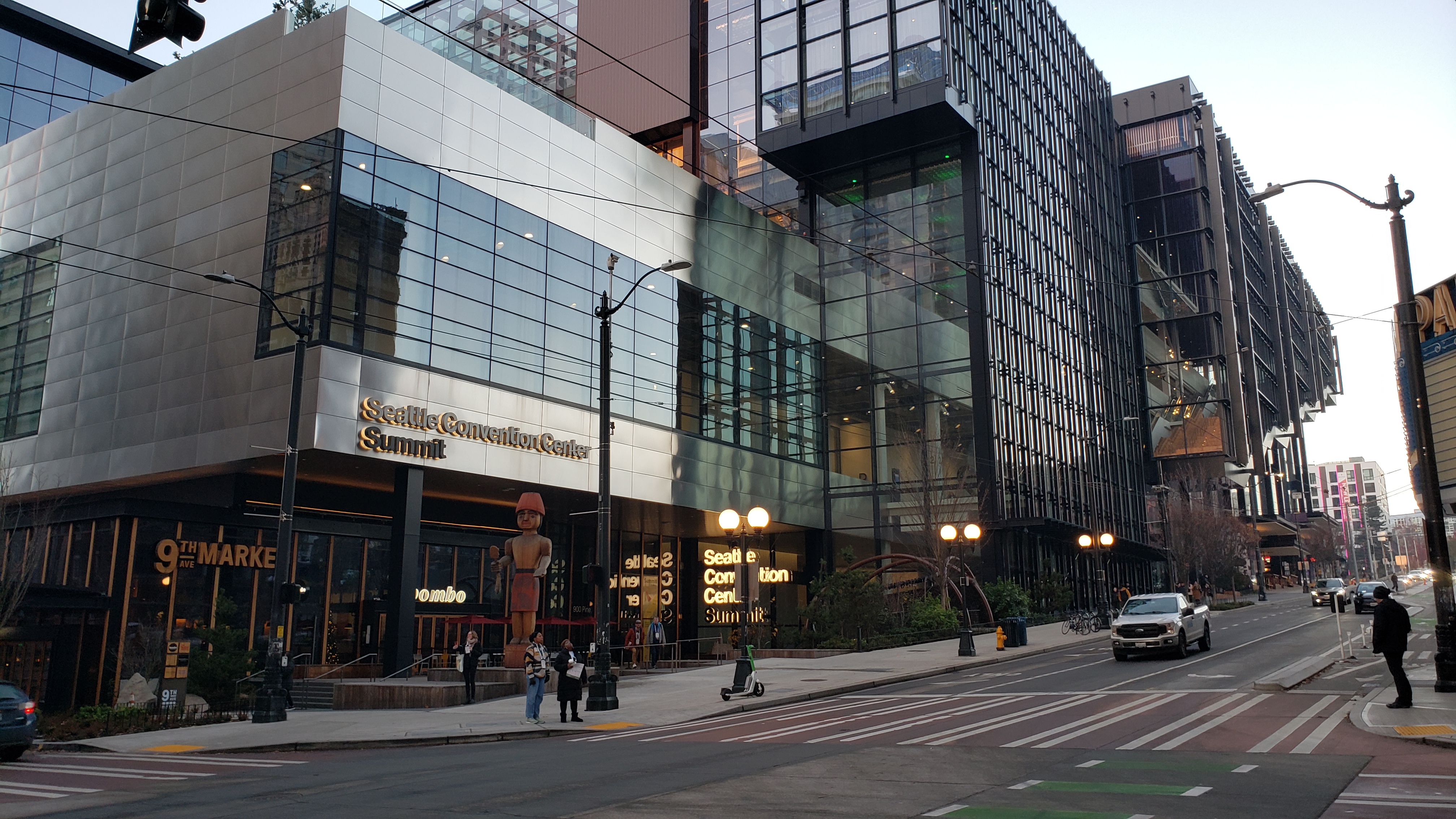
It’s been nearly two years since the Seattle Convention Center’s newest building opened at 900 Pine Street and started hosting events. The structure occupies two city blocks in Downtown Seattle and was likely the most expensive single building in the city’s history, costing $2 billion. It generates millions of dollars per year in local economic benefits from visitor spending.
Another benefit was the substantial public benefits package negotiated by a coalition of community organizations. Many of those benefits have been implemented, and it’s time to check in and see how they are improving the lives of Seattleites. The first part of this posts looks at the benefits projects, and the second part looks at how the deal was made.
Community Package Status
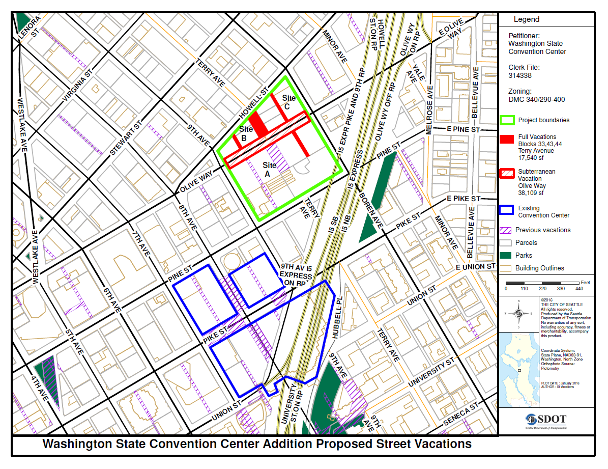
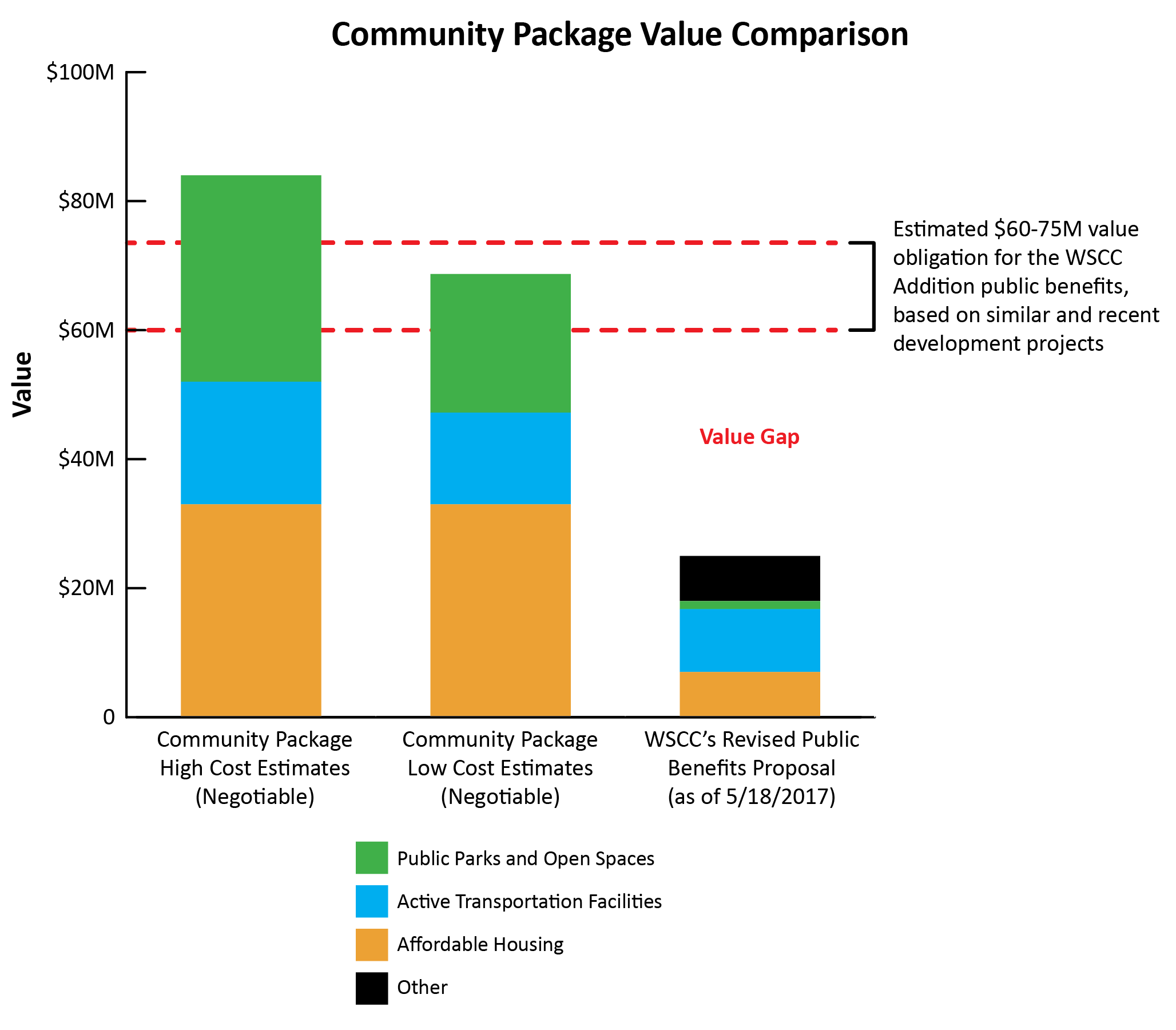
The Washington State Convention Center requested a total street and alley vacation of 1.28 acres, the largest ever requested in Downtown. On top of paying for the value of the actual land, Seattle is unique in requiring developers to pay additional “public benefits” in exchange for losing public right-of-way. Reviewing other large scale vacations in recent years, a newly formed Community Package Coalition estimated the commensurate public benefit value would be $60-75 million. For more history on the coalition and its negotiations, see the second half of this article.
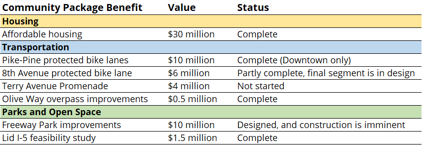
The final Community Package was agreed to in late 2017 and documented in a community benefits agreement. It contained seven initiatives requiring $62 million in direct payments to the City of Seattle:
This was on top of approximately $31 million in other benefits the Convention Center initiated itself or which were required by other processes. These will not be reviewed in detail by this article:
Pike and Pine Streets pedestrian improvements – $10 million
Affordable housing funding from land sale and incentive zoning – $5 million and $4.3 million, respectively
Public open spaces provided beyond code – $8.1 million
Public art – $1.85 million
Lighting for historic buildings – $1 million
9th Avenue frontage improvements – $0.6 million
Olive Way frontage improvements – $0.2 million
The City Council added its own adjustments and conditions, including rounding up the Community Package affordable housing commitment from $29 to $30 million. The final public benefits package, approved alongside the street and alley vacations, is reported as $93 million (see the Convention Center’s fact sheet). Under then-Council President Bruce Harrell, the City Council approved the project in May 2018.
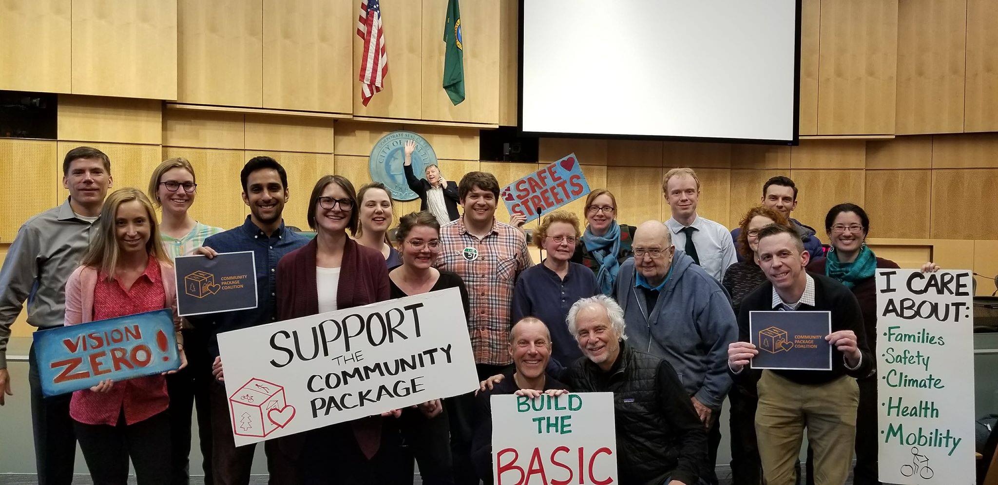
The Community Package Coalition and supporters pose in Council chambers after a public hearing on April 18, 2018.
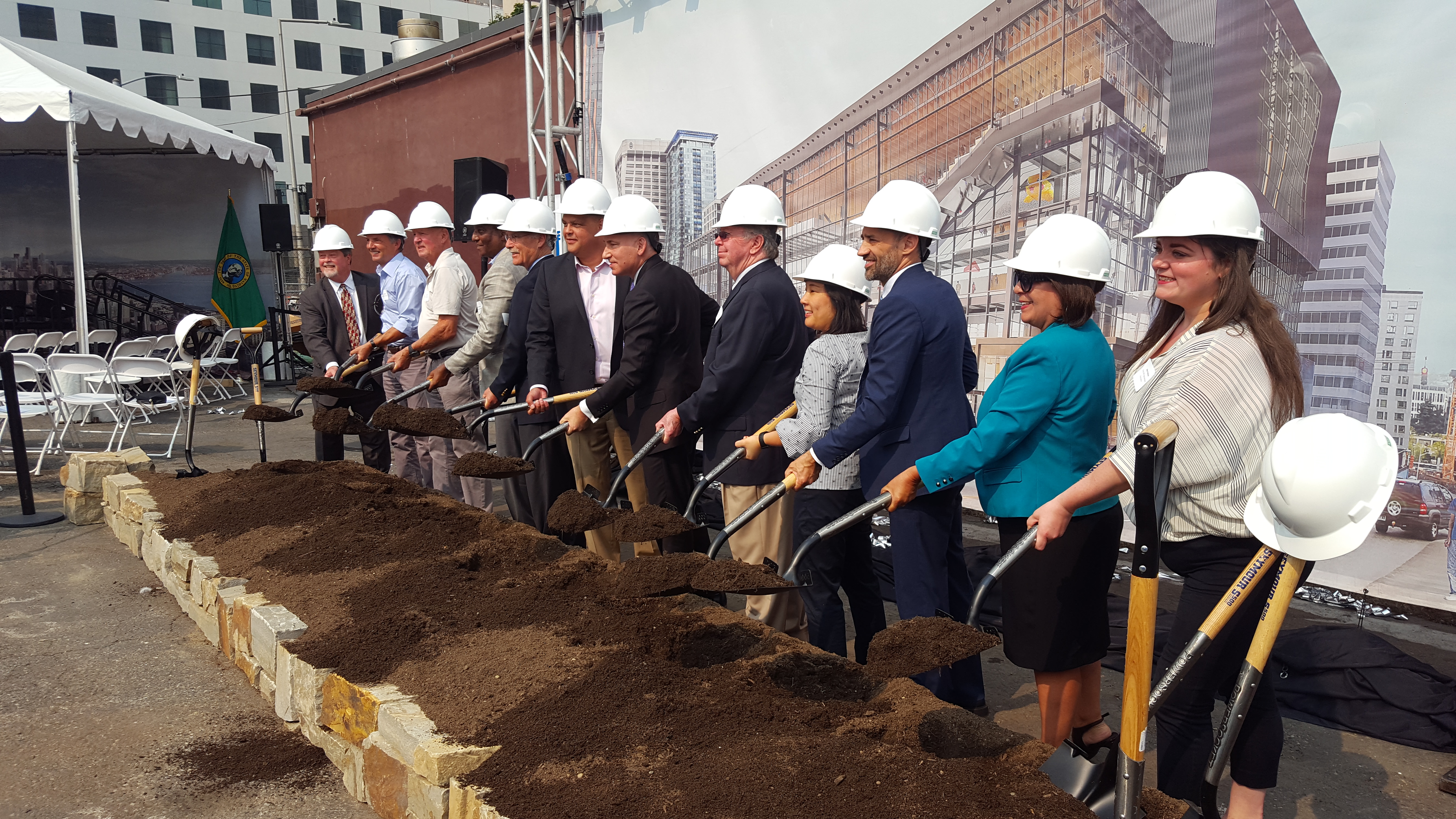
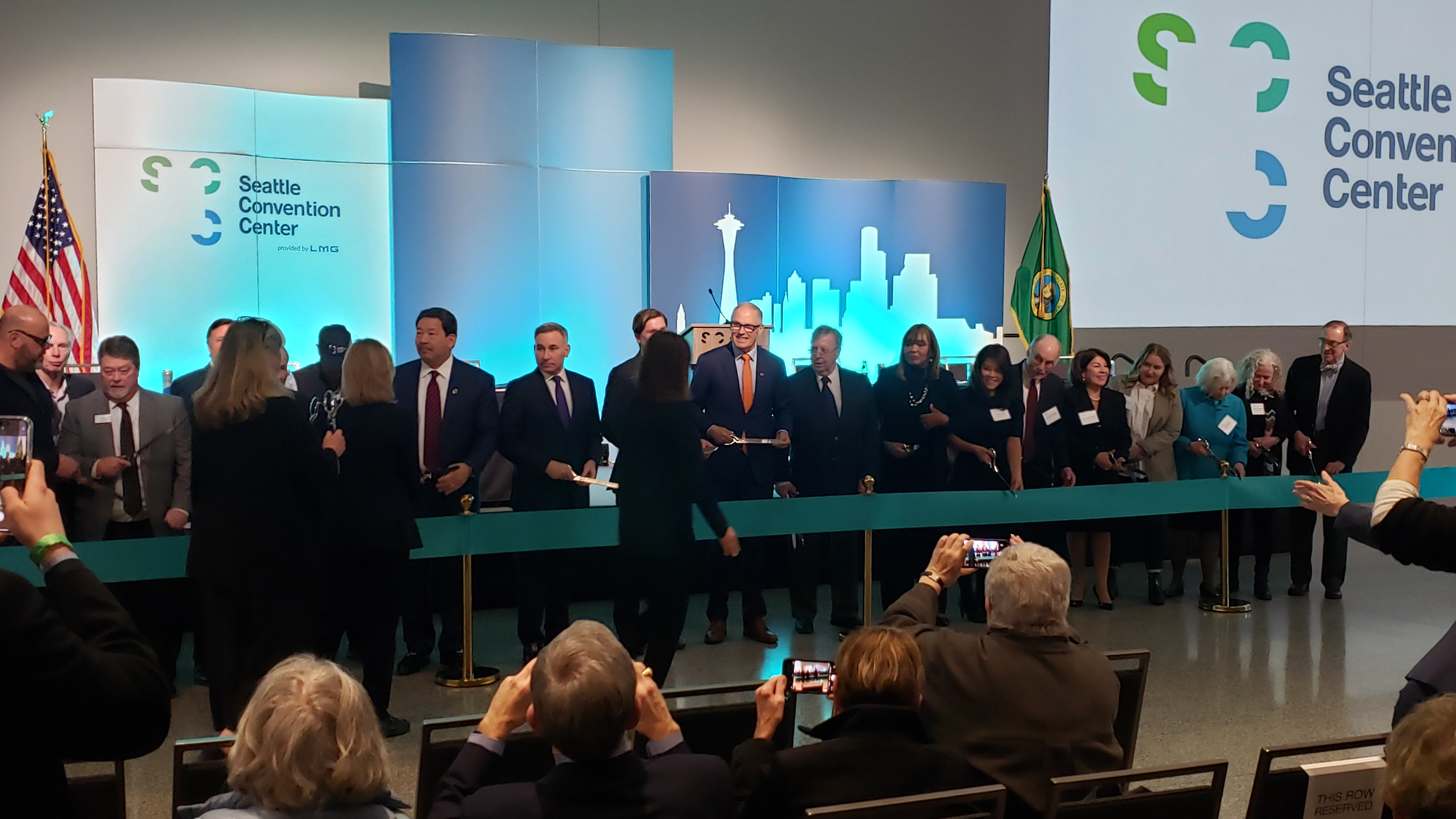
Construction took over four years, breaking ground in August 2018 and finishing with a ribbon-cutting ceremony in January 2023. In the first year of the Covid-19 pandemic the project encountered a massive financial hardship, and King County threw it a lifeline with a $100 million low-interest loan. In the meantime, the Washington State Convention Center renamed itself to Seattle Convention Center, the new building was named Summit, and the original 1988 building is now called Arch.
During this time a lot happened with the Community Package funds.
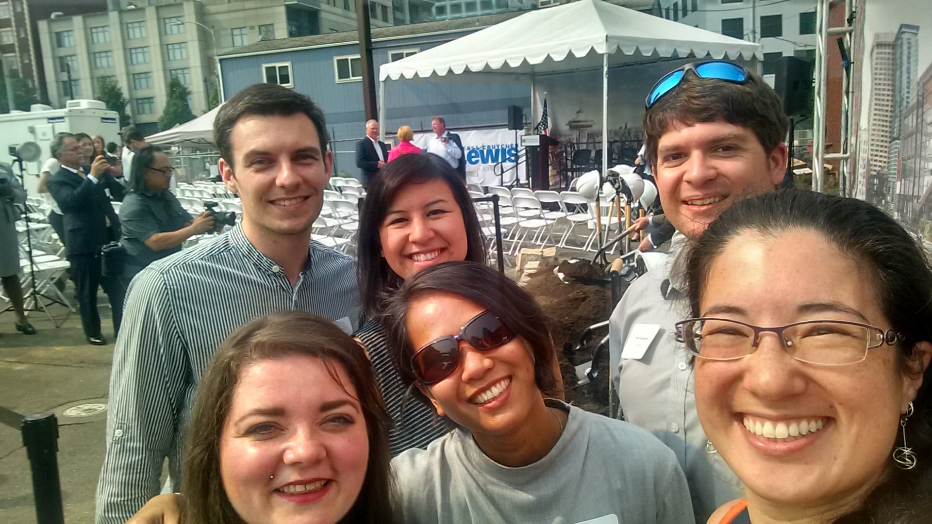
Groundbreaking ceremony.Community Package members at the groundbreaking.The ribbon cutting ceremony.People exploring the new Summit Building during an open house after the ribbon cutting.
Affordable Housing
The Community Package Coalition had sought to fund 300 affordable homes. The City Council conditioned the $30 million for affordable housing be spent on projects with “permanently affordable housing units within the city that are near jobs, transit, public amenities, and services for specific populations.” The Convention Center was authorized to pay in installments over a decade, but it made good on its commitment with an early transfer to the Seattle Office of Housing. The funding was put to use quickly as the City made awards to housing projects in 2018 and 2019.
The funding helped complete or renovate ten non-profit and for-profit housing developments. The map below shows these are spread throughout Seattle and seem to meet the Council conditions.
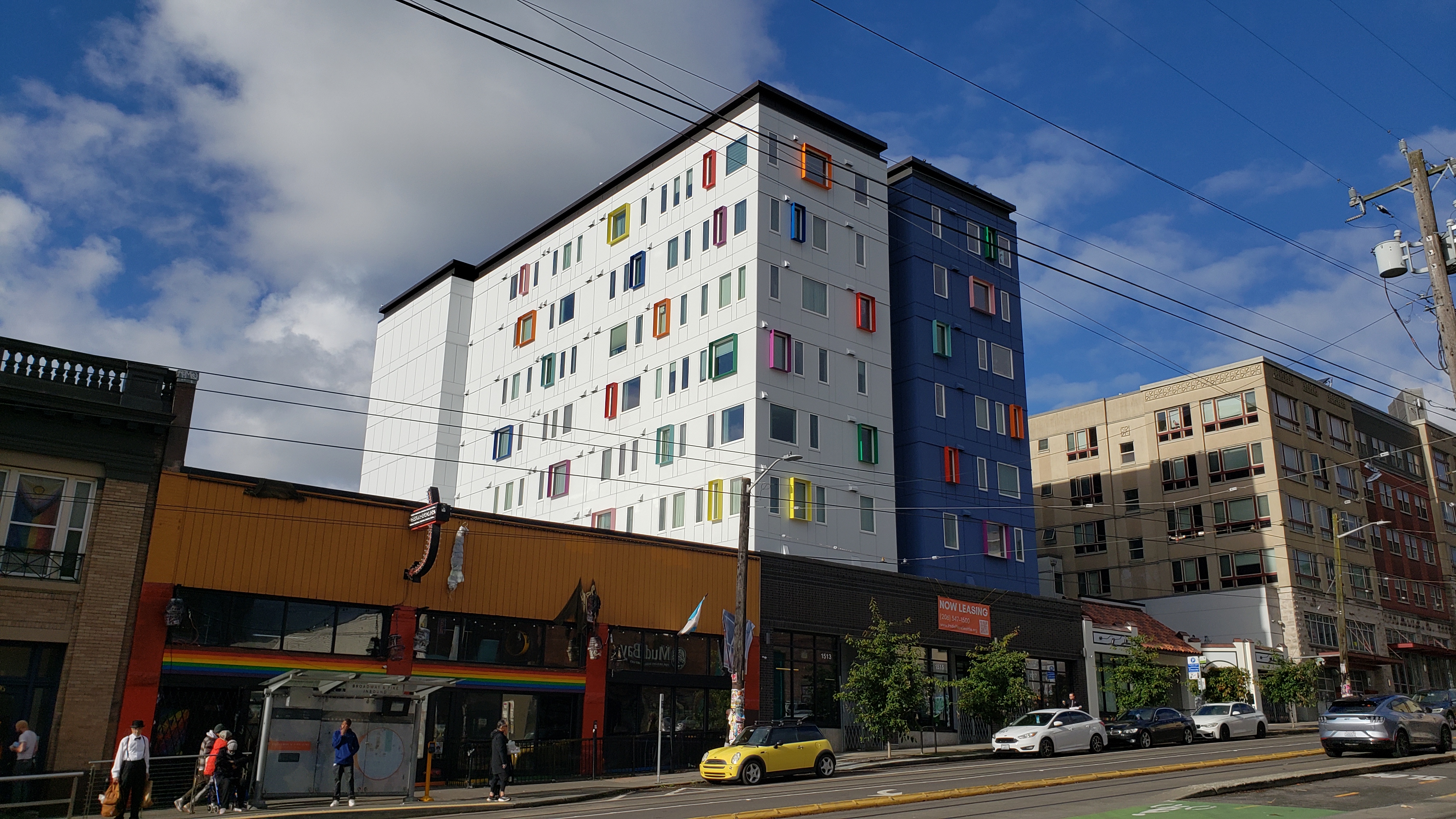
Pride Place – $1.3M
John Fox Place – $0.7M
Northaven III – $0.2M
Chief Seattle Club ?al?al Housing – $0.7M
Maddux – $10.2M
Encore Apartments – $2.4M
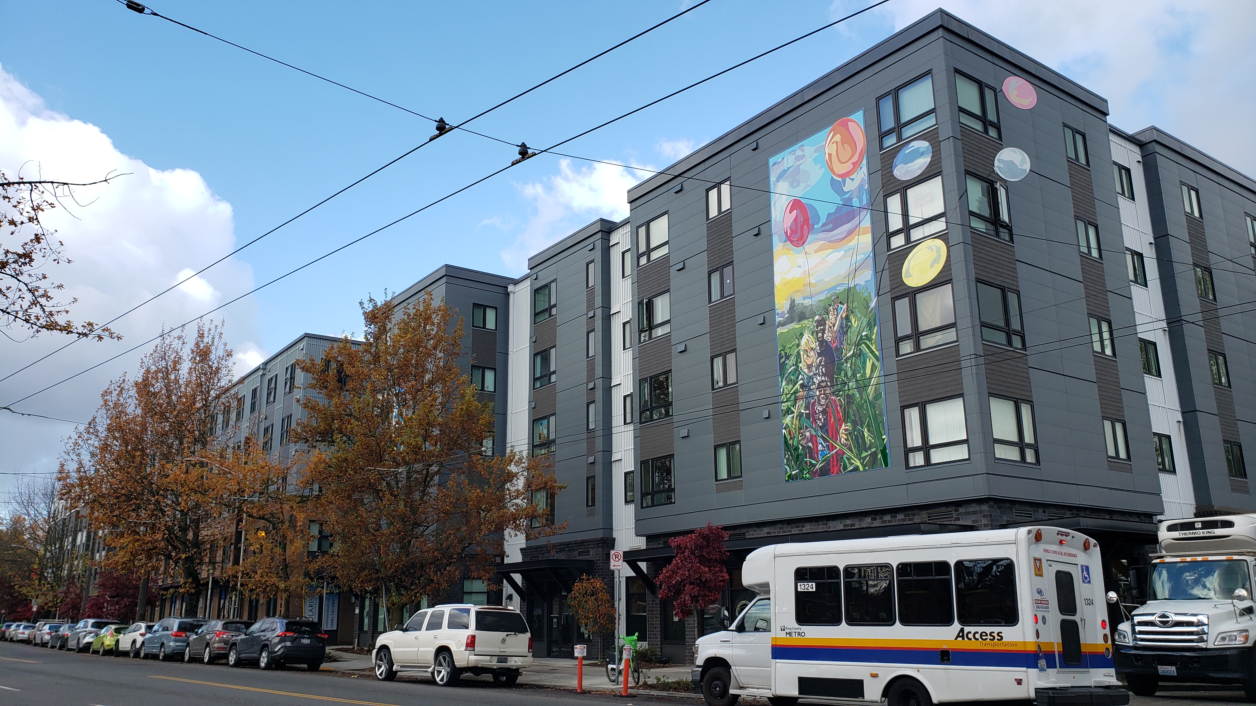
Polaris at Rainier Beach – $8M
Kristin Benson Place – $1M
George Fleming Place – $3.9M
The Madison Apartments – $1.5M (this was an existing building that was later demolished in 2024 after a fire; the City is negotiating next steps which could include redevelopment)
Polaris at Rainier Beach.Pride Place in Capitol Hill.George Fleming Place in Othello.Kristin Benson Place in Uptown.
These contain a total of 1,193 homes. Some of the developments are entirely affordable, while others have a mix of market-rate units. Affordable units are permanently affordable for people making 60 percent or less of the area median income ($81,360 for a family of three, for example). This funding helped many projects get over the finish line, since each low-income housing housing building requires tens of millions of dollars from a range of sources.
The upshot of the Community Package is a lot of doors opened for working class families and under-served populations in Seattle’s most popular neighborhoods.
Lodging tax. A related affordable housing benefit is a new, permanent funding stream from the Convention Center’s lodging tax. To help fund the expanded facility the Convention Center requested the Washington Legislature expand its taxing authority to cover smaller hotels and short-term rentals. Provisions were made to avoid a conflict with Seattle’s new short-term lodging tax passed in 2017, and with the support of the Community Package Coalition the Legislature adopted House Bill 2015 in 2018. The amended law requires that 50 percent of the increased lodging tax revenue go to King County and it must be used for affordable housing. I have an inquiry in to King County about how this funding has been used and will update when I hear back.
Transportation
The Seattle Department of Transportation (SDOT) managed the largest number of Community Package initiatives, totaling $20.5 million across four projects.
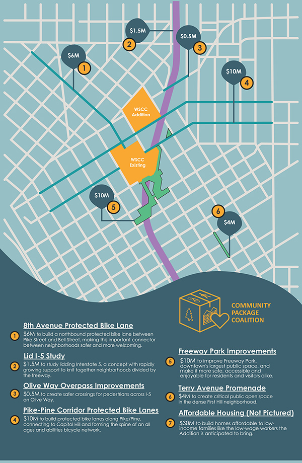
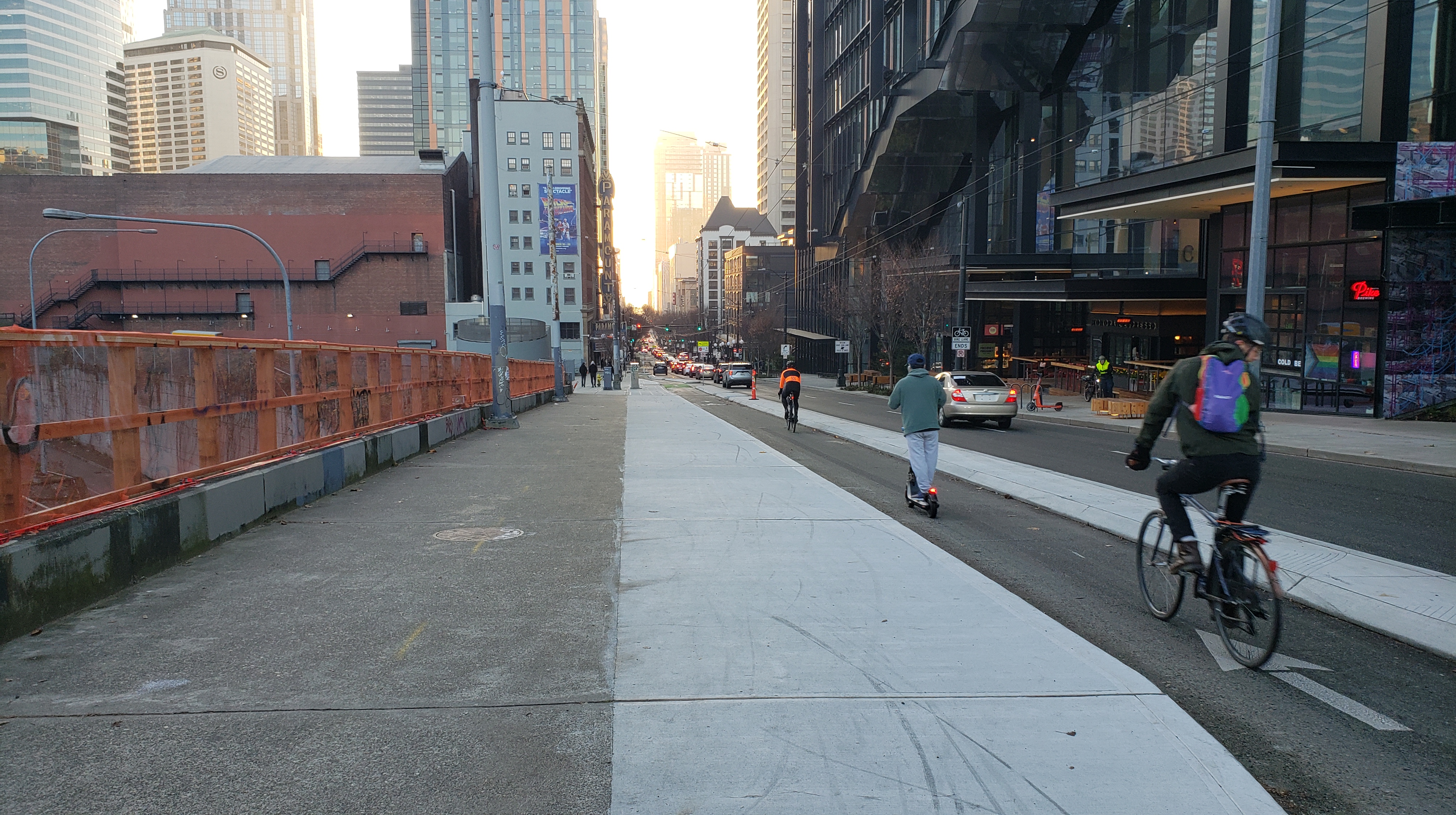
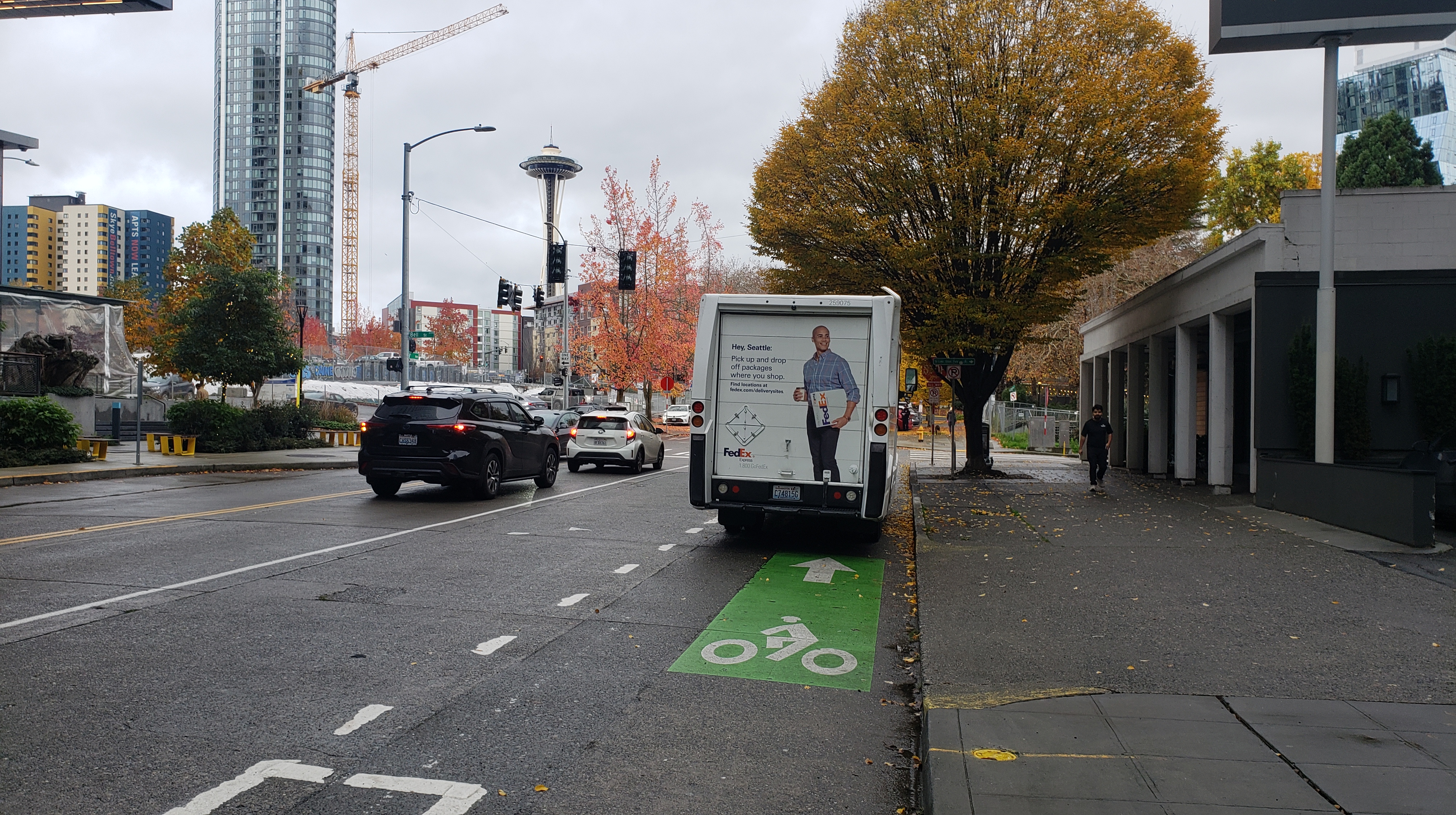
Pike-Pine protected bike lanes. $10 million. This was intended to fund safe bidirectional bike connections between 2nd Avenue and Broadway (15 blocks each direction, 30 blocks total). These core routes were long envisioned in the Seattle Bike Master Plan, and then had more urgent advocacy as Seattle Neighborhood Greenways and Cascade Bicycle Club pushed a “basic bike network” for central Seattle in the mid-2010s. There is a direct relationship to the Convention Center, with Pike and Pine Streets running through the campus. The timing was also good, as the Waterfront Seattle project was planning to improve east-west access to the waterfront.
In 2018 the City used $1 million of the Community Package funding to build temporary paint-and-post protected bike lanes between 2nd and 7th Avenues. In 2019, the City used other non-Community Package funding to also install paint-and-post protected bike lanes on the east part of Pike Street, from 7th Avenue to Broadway, with a promise to upgrade them to concrete barriers.
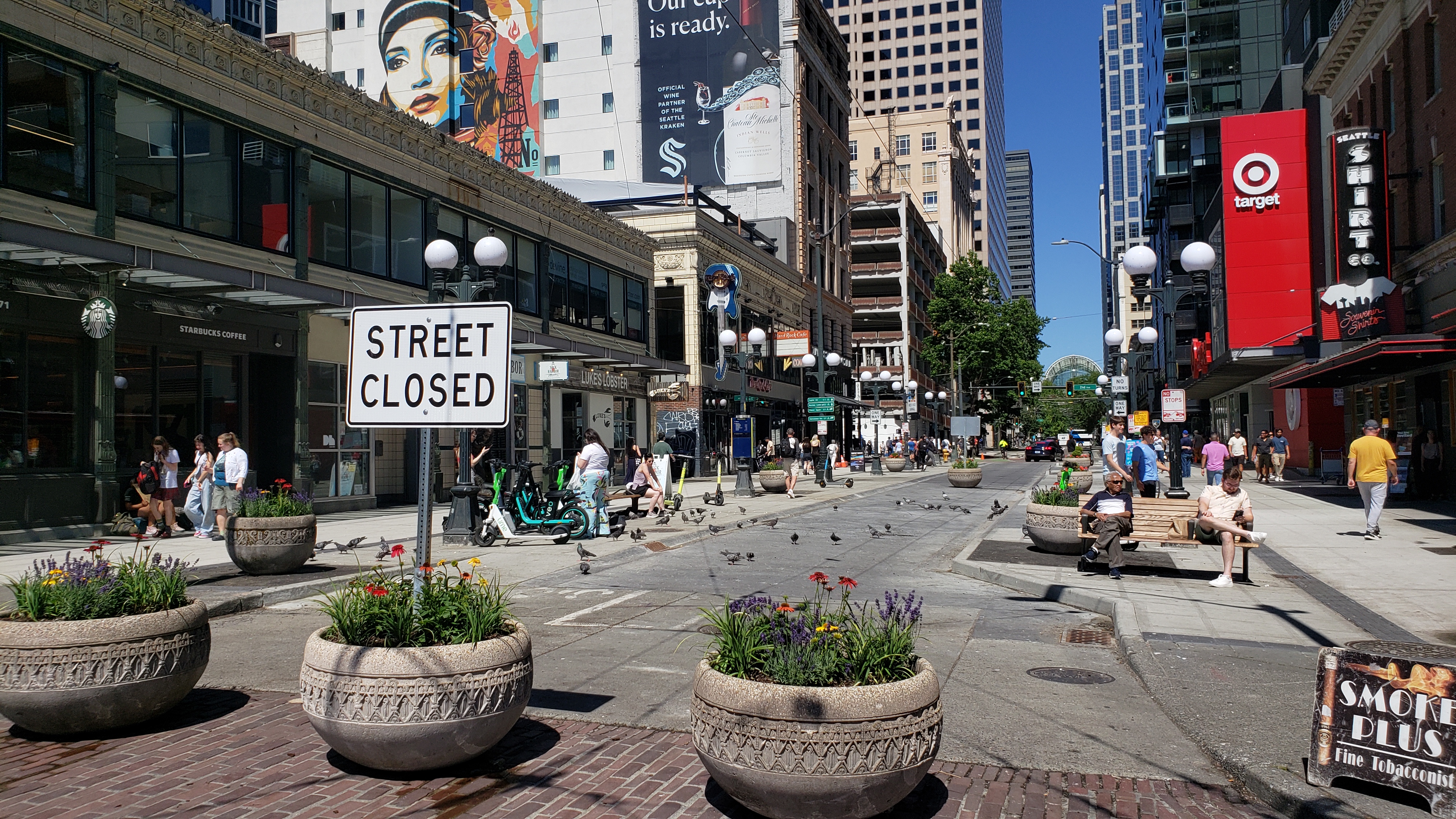
Starting in 2023, the remaining $9 million in Community Package funding was used to build permanent concrete-protected bike lanes only between 2nd Avenue and Melrose Avenue (approximately two-thirds of the promised distance). The bike lane construction was part of a total $40 million revamp of Pike-Pine in which crews also rebuilt crosswalks, switched some blocks to one-way traffic, added new furniture, and created the bike lane barriers. Midway through construction, the mayor’s office announced part of Pike Street and 2nd Avenue will be closed to vehicles as a pedestrian space pilot project.
The Pike-Pine construction work finished in 2024. The particular design features of Pike-Pine, especially in Capitol Hill, had considerable community advocacy led by Central Seattle Greenways.
Pike Street closed to vehicles and opened to people and pigeons between 1st and 2nd Avenues.Pike Street protected bike lane.
The Community Package funding was not enough to build concrete-protected bike lanes east of Melrose Avenue, as originally envisioned. In a 2021 letter to the Community Package Coalition, SDOT and the Office of the Waterfront reported “…all the funding is being used [in Downtown] and it is not possible to fund additional improvements east to Broadway within this budget without cutting scope…At this time, SDOT’s priority continues to be extending and connecting an all ages and abilities bicycle network across the city, and we have not prioritized further upgrades to the Pike Street PBLs.” The City did not respond to a request for further details on why the funding was inadequate.
One other wrinkle occurred on the Pike Street overpass above Interstate 5. At first, new engineering standards from the Washington State Department of Transportation (WSDOT) did not permit the weight of additional concrete. After further structural calculations, WSDOT determined the original design could work. On one side of each of the two overpasses the sidewalks have roughly doubled in width and the bike lanes are protected with concrete barriers.
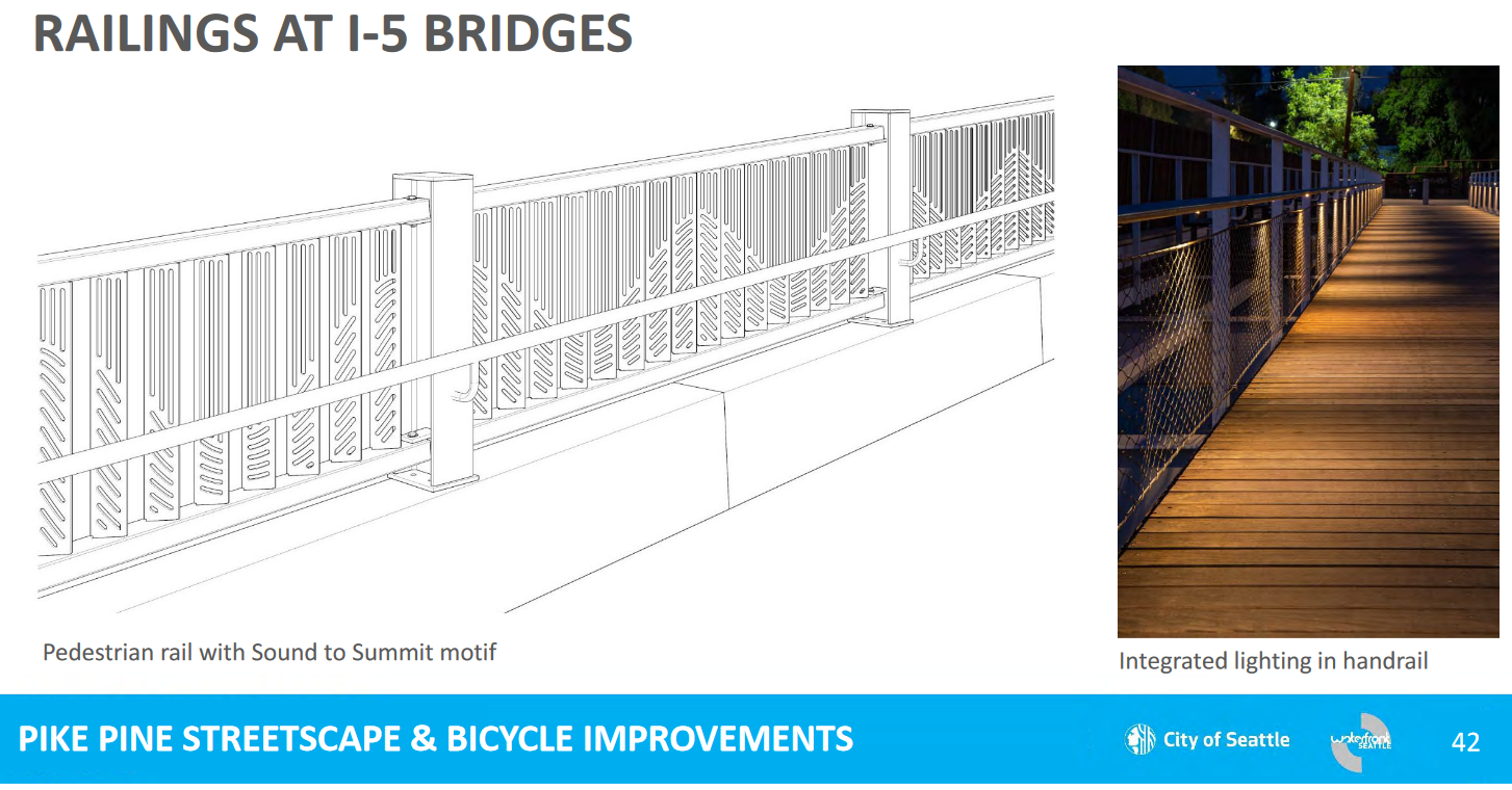
A finishing touch is underway. The Pike-Pike I-5 overpass railings are being replaced with artistic fencing as part of the separate pedestrian improvements.
Design for the new railings on the Pike and Pine I-5 overpasses.Pine Street overpass, looking west at widened sidewalk and protected bike lane. At left is where a new railing will be located.
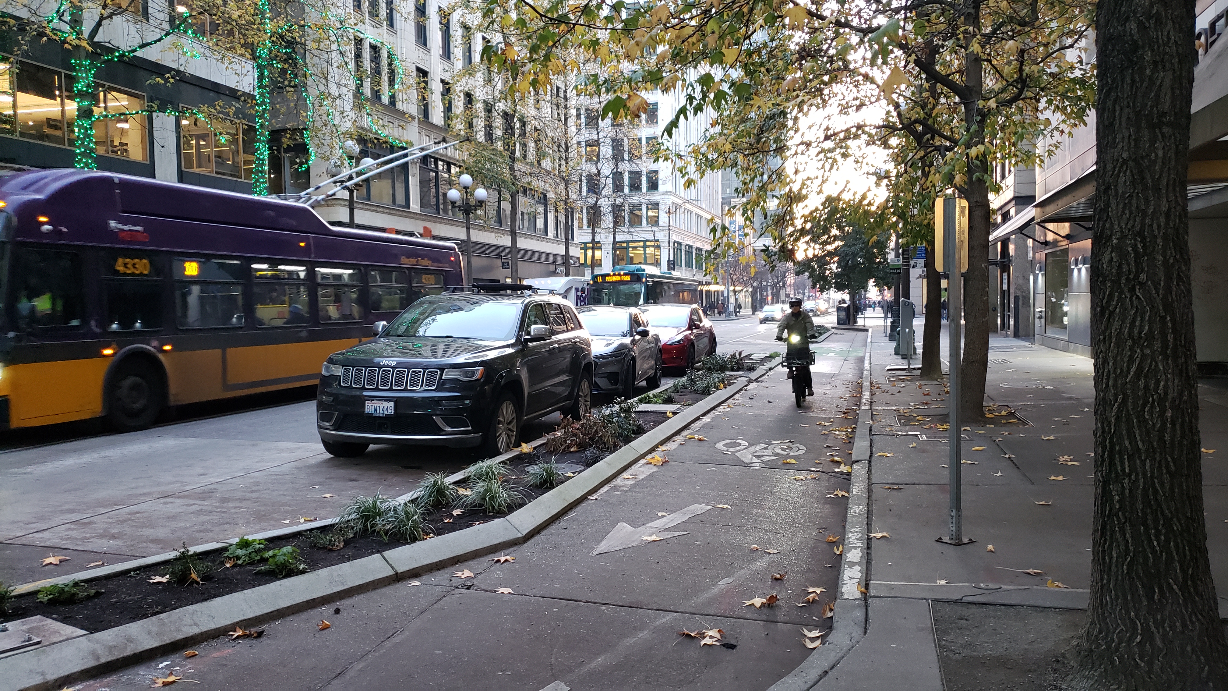
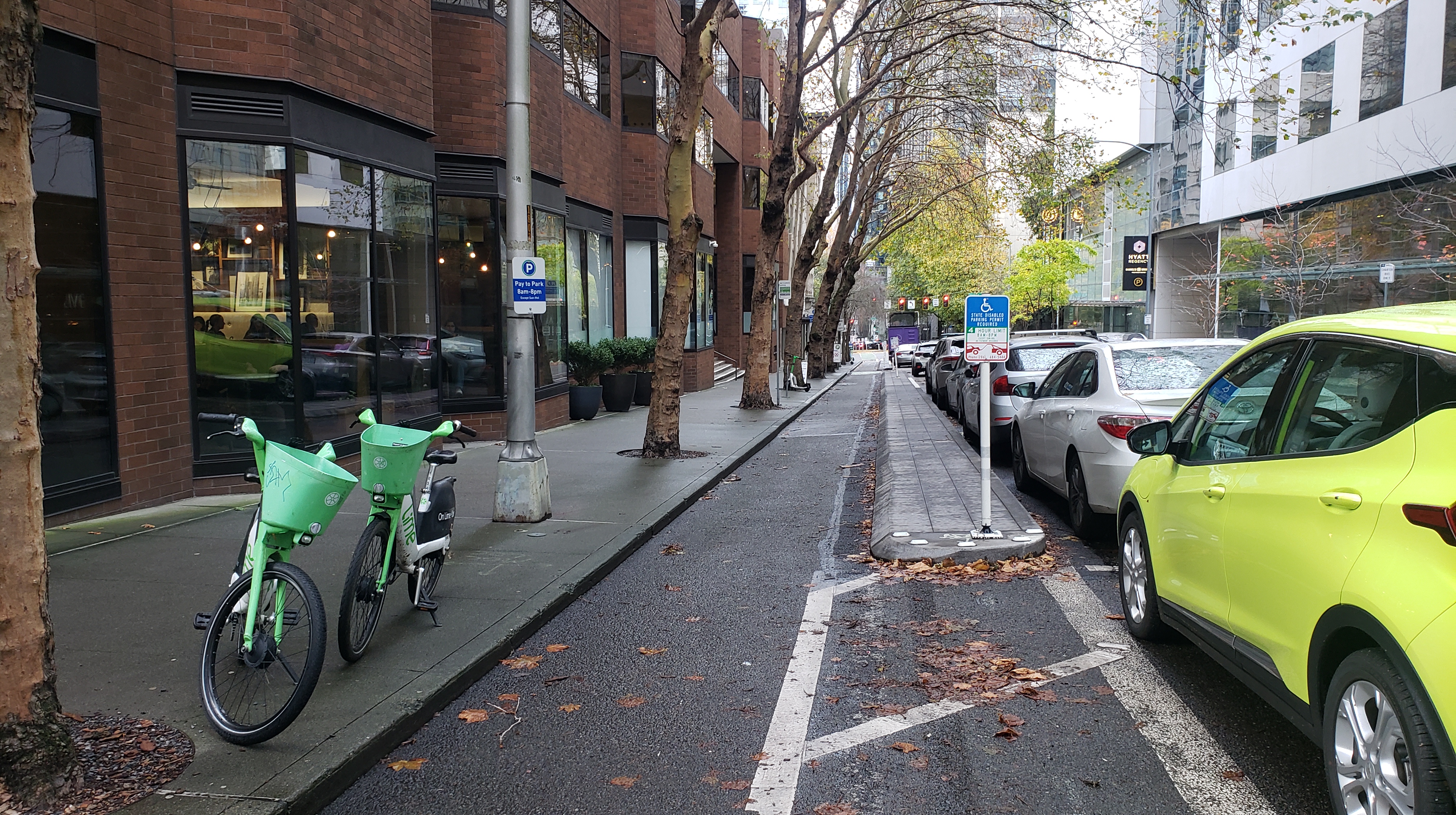
8th Avenue protected bike lane. $6 million. Envisioned between Pike and Bell Streets (seven blocks). There was an existing paint-and-post bike lane (built in 2019), and in 2023 construction finished on upgrading to concrete protection for five blocks between Pike Street and Westlake Avenue. During project design, SDOT determined that paint-and-post on the remaining two blocks between Westlake and Bell was adequate for implementing the Center City Bicycle Network vision, and that concrete protection on those blocks would create “significant impacts to the corridor, both operationally and in relation to land use along the northeast side of 8th Avenue.”
However, when contacted for this article, SDOT’s tune had changed. They now say “SDOT is currently in the design phase to build protected bike lanes on these two blocks to connect to Bell Street. There is sufficient funding from the Convention Center to cover the cost of construction for this work, and SDOT is hoping to finish this segment in the next couple years.” Further information is not yet available on the project website.
The current 8th Avenue bike lane is mostly on the left side of a one-way street, but on the last block north of Virginia Street it makes a switch to the right side of the street before ending at a turn pocket on Westlake Avenue. On the other side of Westlake, 8th Avenue is a two-way street and presumably the bike lane will continue being one-way northbound and end at the crosstown bike lanes on Bell Street. This two block stretch could certainly use the improvement as demonstrated by car maneuvers and parked vehicles on a recent visit.
The 8th Avenue bike lane north of Howell Street, where it runs on the left.The 8th Avenue bike lane north of Virginia Street, where it runs on the right.The existing “door” zone bike lanes on 8th Avenue north of Virginia Street.Delivery vehicle blocking an unprotected bike lane on 8th Avenue.
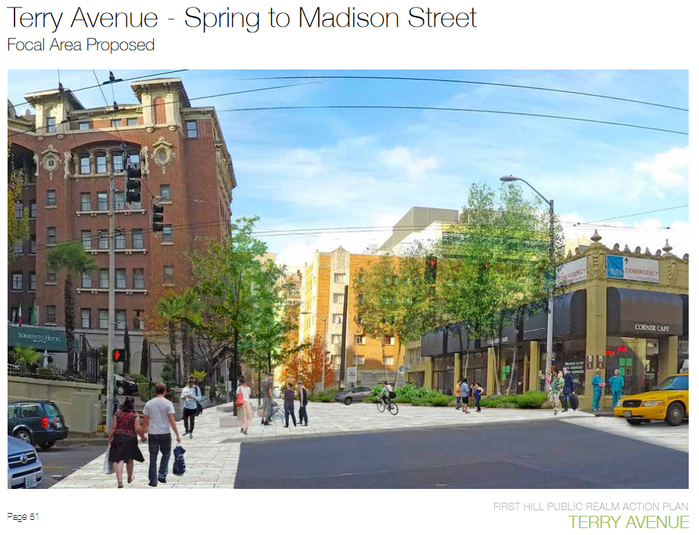
Terry Avenue pedestrian street. $4 million. First Hill continues to see rapid growth and new skyscrapers, even as it has long sought additional open space to serve its high density of residents. The acquisition of private land for public use has been increasingly expensive here. In recent years the community has embraced public right-of-way as an alternative opportunity for open space. Endorsed by the City in 2015, the Terry Avenue Concept Plan seeks to create 40,000 square feet of new open space by establishing a pedestrian-priority street on seven blocks of Terry Avenue between Spring and Terrace Streets. The funding from the Community Package will fund construction of two blocks between Cherry and Marion Streets.
Terry Avenue is one of the few “Phase 3” projects in the community benefits agreement, which gives the Convention Center ten years to make the payment. Following the 2018 groundbreaking, the Seattle Department of Transportation estimates the Terry Avenue project will be completed in 2028. The project design is being managed by the First Hill Improvement Association.
Rendering of the Terry Avenue pedestrian street, looking north from Madison Street. Image courtesy of First Hill Improvement Association.
Olive Way overpass improvements. $0.5 million. This small amount of money has a surprisingly complex story.
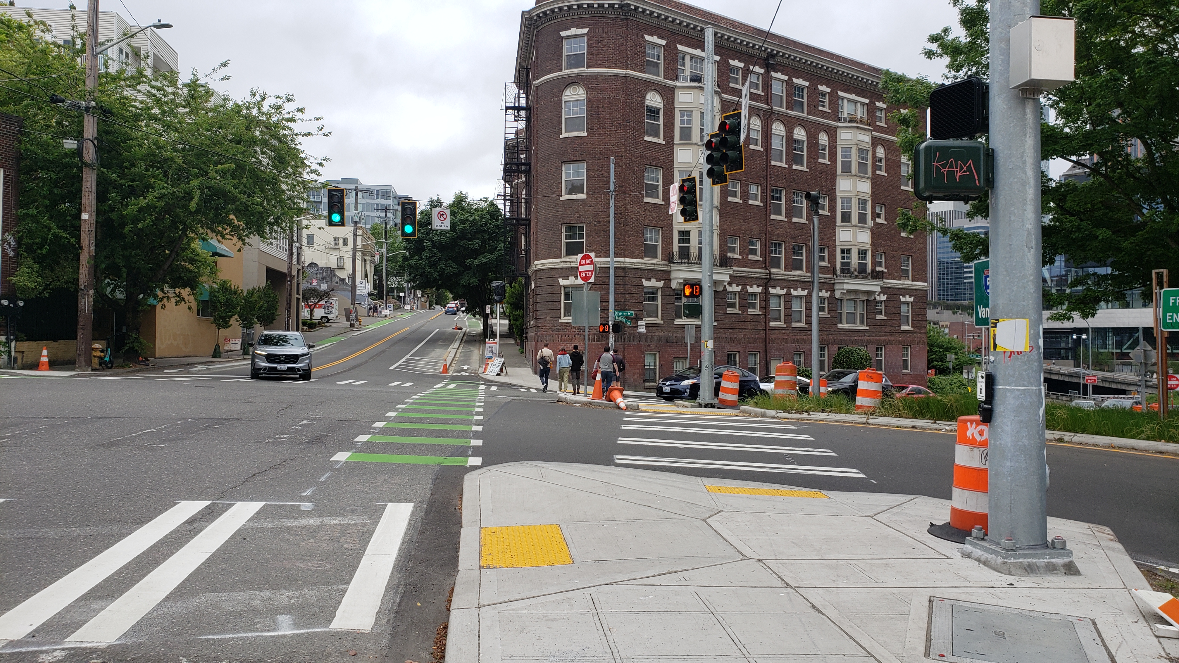
The Community Package Coalition endorsed a 2016 letter from neighborhood advocates (which followed an article I wrote) that requested safety improvements for people walking over the Interstate 5 overpass. The on-ramp and off-ramp are designed for high-speed traffic and have been targeted for improvements since at least the 1998 Capitol Hill Neighborhood Plan. Olive Way is a direct pedestrian route between the Convention Center Addition and the businesses and nightlife offerings on Capitol Hill. A long-term fix could be squaring up intersections to help cars slow down. However, the final public benefits agreement was vague on how the the $0.5 million should be used.
As the Convention Center Addition was being built, SDOT was designing upgrades for biking and walking at the Melrose Promenade project. Melrose crosses Olive next to those I-5 ramps. In late 2018, SDOT staff reached out to me as a representative of the local advocates to inquire about using the Convention Center’s public benefits funding for Olive Way.
The money was a well-timed opportunity for SDOT to efficiently add “enhancements” to their baseline design for Melrose. They were also on a time crunch for spending a $3 million federal grant. After a few months of discussion, me and the advocates agreed to SDOT’s proposal. Compared to the base design, the enhanced features for the Melrose/Olive intersection include:
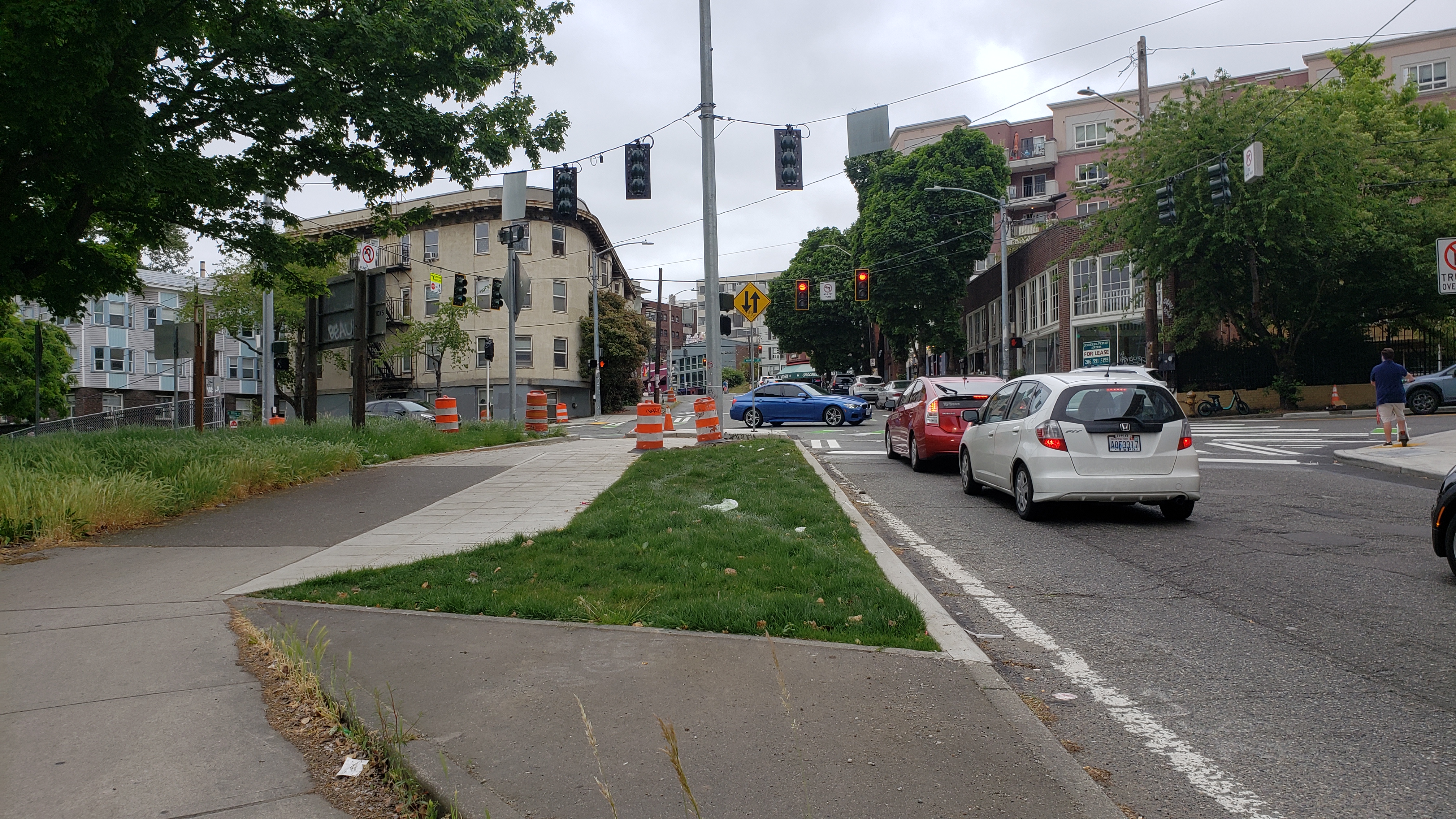
A new crosswalk and curb ramps on the west side of the intersection. This was a big win for people who used to wait three light cycles to navigate the intersection. This also incurred some costs due to traffic signal modifications.
The Interstate 5 on-ramp shifted a few feet south to make space for a pedestrian refuge and make a tighter turn for vehicles, which can force lower speeds.
I personally advocated for the removal of a few unusual parking spaces situated in the middle of the interchange island, which were replaced with grass landscaping (I also suggested street trees but WSDOT had sight distance concerns).
The sidewalk on the island in the interchange was repaved.
Soft costs included design, traffic control, and contingency.
The new crosswalk and relocated freeway on-ramp at the Melrose/Olive intersection.The landscaped area that replaced parking spaces.
I was not successful in using the funding to also build more curb bulbs in a parking lane due to the engineers’ concerns around peak hour traffic flows. Overall, however, the Melrose project’s timing was fortuitous, and seeing results on the ground is better than waiting a long time for WSDOT to cooperate on the original intent for ramp redesign. This is illustrated by the multi-year saga to simply install a pedestrian-activated flashing beacon.
Under a $75,000 2017 Your Voice, Your Choice grant the crosswalk on the Olive Way off-ramp was slated to get a beacon like the one at the on-ramp. The schedule has slipped repeatedly for years and the timing of the installation is still uncertain. SDOT staff have cited problems with the foundation work, cycling through multiple designers, procuring the equipment, and forming a maintenance agreement with WSDOT. The bureaucratic hurdles may have been foreseeable given the 2016 signal incident I also chronicled.
Digression complete. Most of the Melrose project finished construction in 2023.
Airspace lease. On the topic of WSDOT, a related benefit is the airspace lease payments that the Convention Center will pay for a small part of the Summit building to cantilever out above Interstate 5. The Convention Center has a 66-year lease with WSDOT (2018 to 2084) for airspace rights. WSDOT rent credits will off-set lease payments through 2028, and then annual lease payments are $475,000 and increase annually based on CPI and an adjustment to market every 15 years.
Parks and Open Space
Freeway Park improvements. $10 million. This is an active capital project with Seattle Parks and Recreation. The department is working on final construction documents and aiming to hire a contractor for starting the work in 2025. Construction could be done in time for the park’s 50th anniversary on July 4, 2026.
The timeline has been repeatedly pushed back due to the park’s national landmark status acquired in 2019, the pandemic, and increases in construction costs that required multiple downsizes in project scope. The design team identified $23 million in ideas for park upgrades while only about $6 million is currently available for construction (after soft costs like design and permitting). Of the total, $750,000 has also boosted the nonprofit Freeway Park Association for park staffing and programming, which will run out soon.
These key physical improvements are set to go forward:
A new public restroom, storage, and concierge building at the park’s main open space in Seneca Plaza
Improved access into the park’s fountains at Seneca Plaza
Restoration and reopening of the long-shuttered restroom at the park’s upper lawns
New wayfinding signs
New and upgraded lighting
Landscape, irrigation, and drainage improvements
Rendering of improvements to Seneca Plaza at Freeway Park. Image courtesy of Seattle Parks and Recreation.
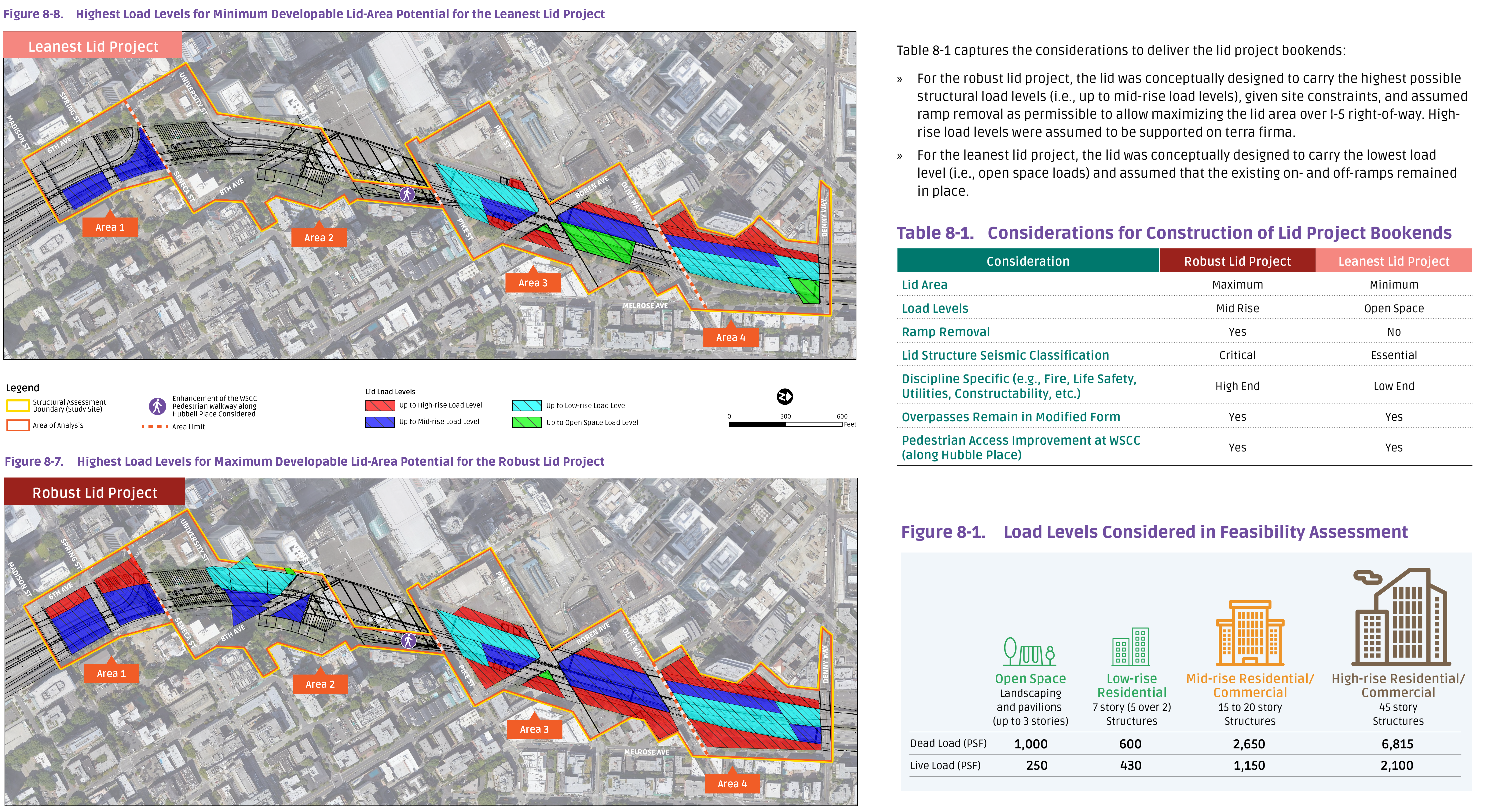
Lid I-5 Feasibility Study. $1.5 million. One of the most straightforward results, this study was completed in 2020 by the Seattle Office of Planning and Community Development (OPCD) and a large consultant roster.
This was an unusual public benefit in that the money went to an intangible project. It is a written study rather than a physical benefit on the ground like a park or a bike lane. The Seattle Design Commission was a visionary participant in the process when they decided the potential benefits outweighed the risks, and they were proved correct. The study found that lidding more of I-5 north and south of Freeway Park is not only possible, but would be worthwhile for the social, environmental, and economic benefits it could bring to Seattle. Up to 17 acres of new public “land” could support anything from parks to commercial development. A summary and the final report files are on the Lid I-5 website.
The Convention Center money has already been leveraged as the Lid I-5 project advances: in 2023 the Washington Legislature provided $200,000 to expand upon the study and in 2024 Seattle OPCD secured a $2 million federal Neighborhood Access and Equity grant to do additional planning and outreach work.
A personal note on the Lid I-5 work, which I lead with several other Seattle residents. The year the public benefits were finalized, 2018, was the most intense period of advocacy I’ve ever experienced. At the same time negotiations were moving towards City Council action, the Lid I-5 Steering Committee was leading a yearlong charrette with dozens of volunteer designers and clients. The charrette program was funded by a $48,000 Department of Neighborhoods grant and included five major public workshops and events and resulted in conceptual designs and books that the campaign still uses today.
Collection of graphics illustrating structural considerations in the I-5 Lid Feasibility Study.
A Guiding Example
The collaboration between an ad-hoc collection of community groups and power brokers ought to set the stage for future major developments. No party got everything they wanted, but each party took away a win that helped many good projects move forward.
One idea brought up too late in the process was increased public access, and it’s something I hope can be addressed a future juncture. Unlike most of Seattle, the central neighborhoods lack a standard publicly-operated community center that offers a variety of meeting spaces at low or discounted rates for residents. The Convention Center could fill that role for many types of meetings and events, but costs are prohibitive for non-profit community groups. In Lid I-5’s experience, a modest room can rent at $1,000 or for just a few hours. The Convention Center explained they do not offer free meeting space because they “operate as a business.”
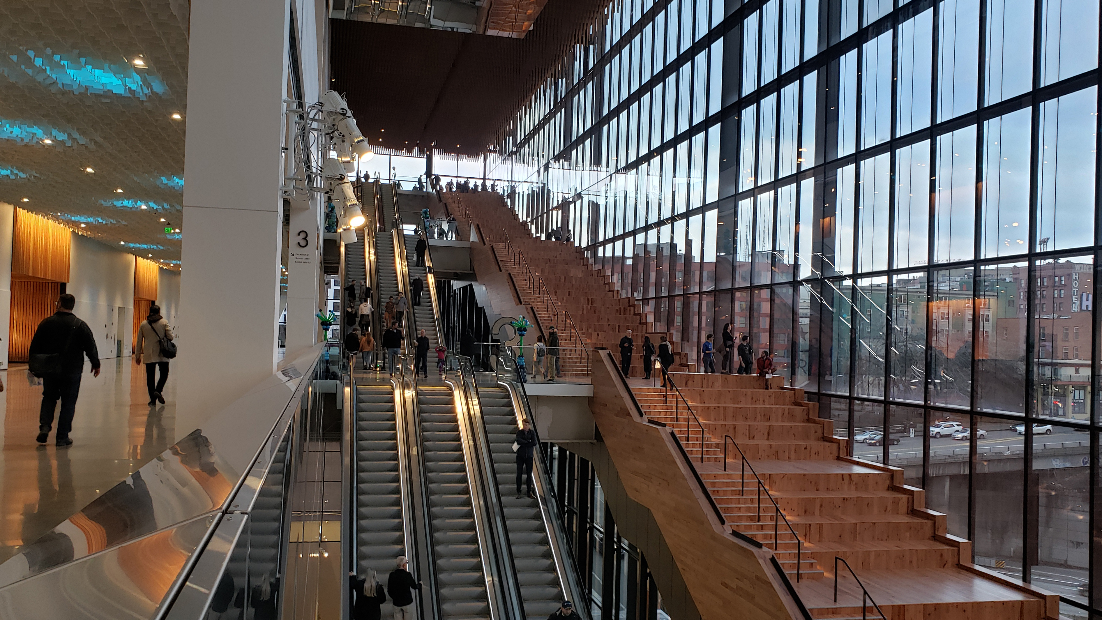
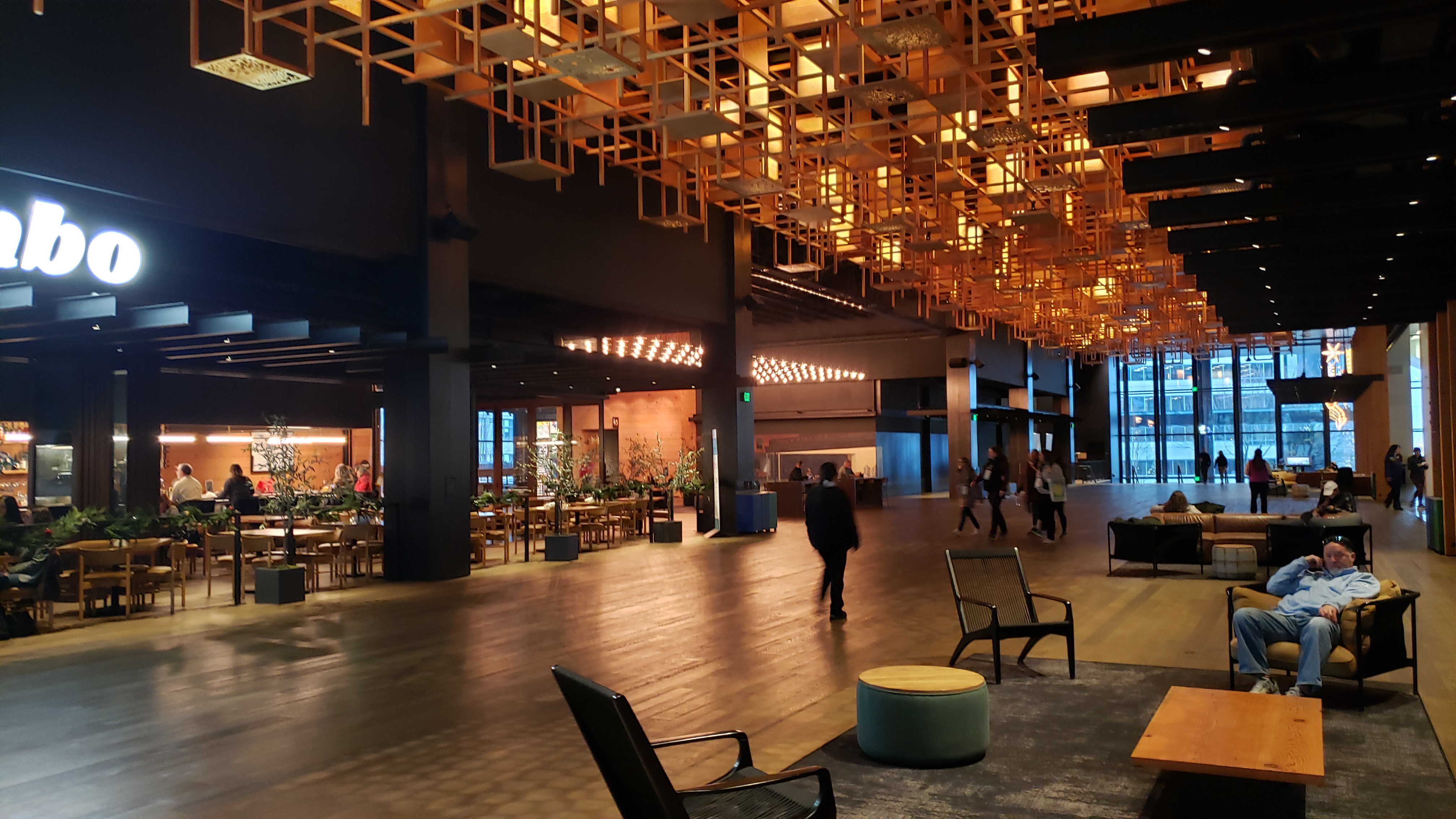
The ground-level retail lobby of the Summit building.
A more personal interest is increased physical access to this ostensibly public facility built using tax dollars and a bailout. The general public is limited to the ground-level retail spaces where people are most welcome if they spend money. The obvious physical opportunity is to invite people to explore the Pine Street “grand staircase”, which offers fun and beautiful seating with spectacular views of the city. It might be reasonable to open this when there is not a full-building event going on, but for now the Convention Center says “Summit’s Hillclimb stairs are within private event space and available for client use only.”
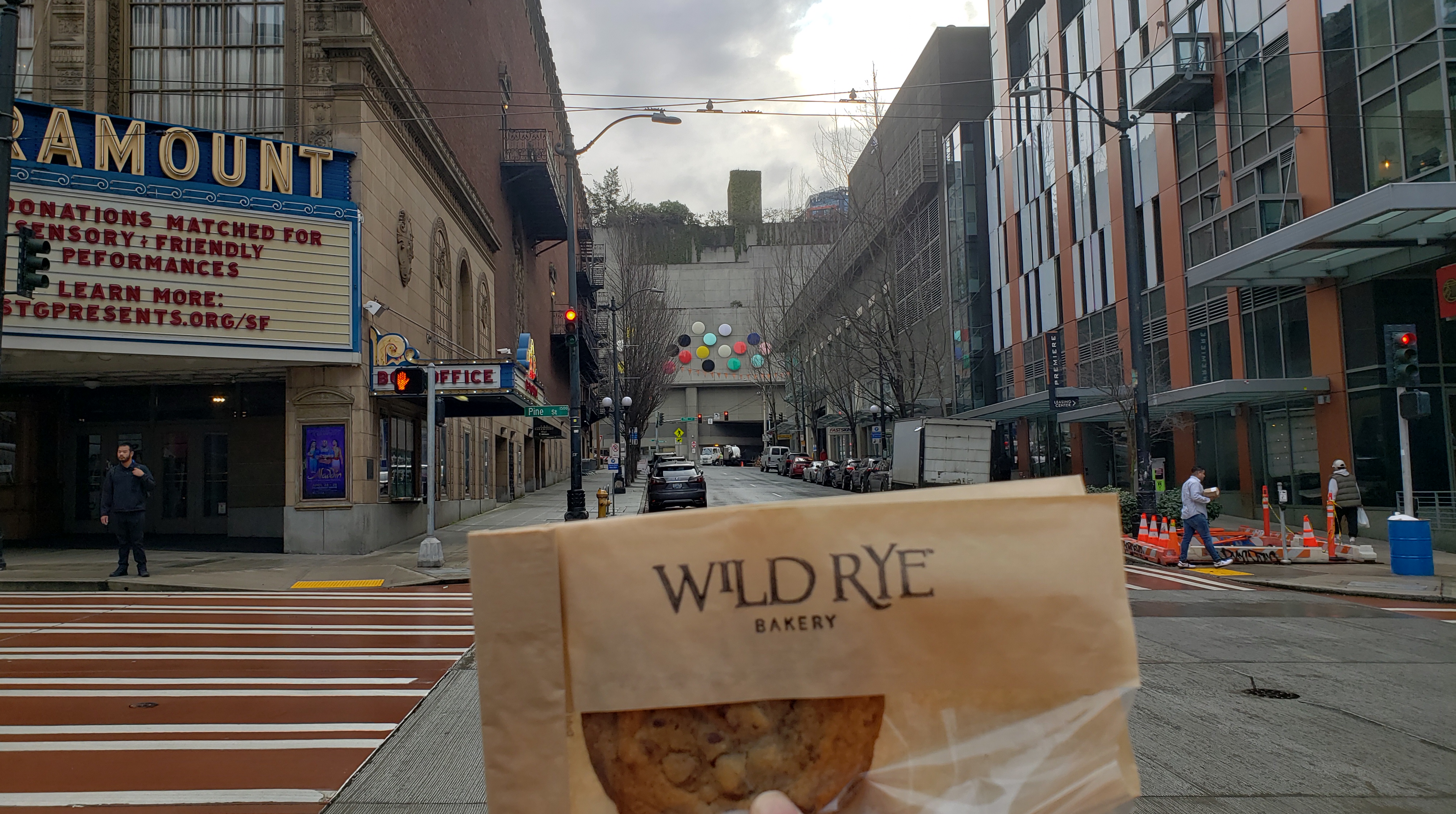
One delicious bit of public access that has been provided is the Wild Rye bakery at the corner of Olive and Boren. This is a new storefront operated by the Convention Center’s catering department. Anyone can now get one of their tasty cookies for muffins for a reasonable price. Other retail so far includes a new streetside outpost for Monorail Espresso, Pike Brewing, Russian bakery Piroshki Piroshki, and Italian restaurant Bombo. The lobby also has public restrooms.
A cookie from Wild Rye, and in the distance is new public benefit artwork installed on the Arch building.
As it is, the Convention Center’s national business clients will benefit greatly from the building. It is a remarkable architectural and engineering feat by design firm LMN and contractor Clark Construction, with high-end interior finishes and artwork, soaring ceilings, and spacious and comfortable meeting rooms. The agency estimates its facilities inject hundreds of millions of dollars into the local economy annually from out-of-state visitor spending. Across its entire campus the Convention Center organization employs 160 full-time staff plus other on-call and part-time vendors.
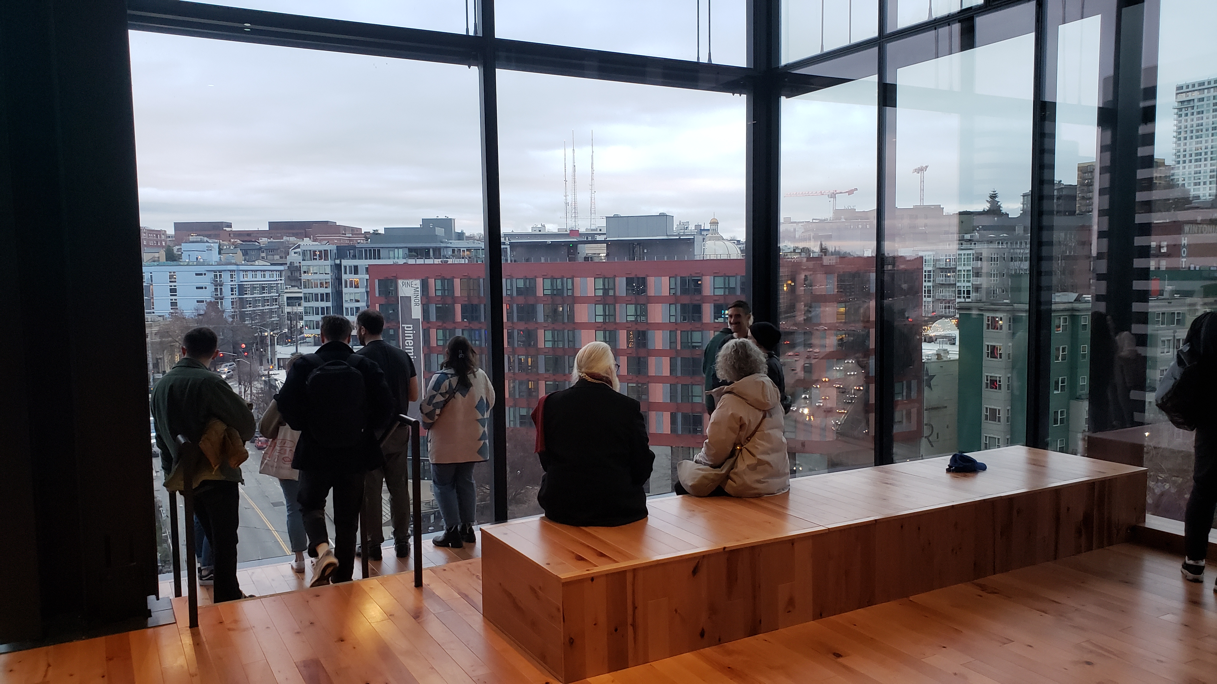
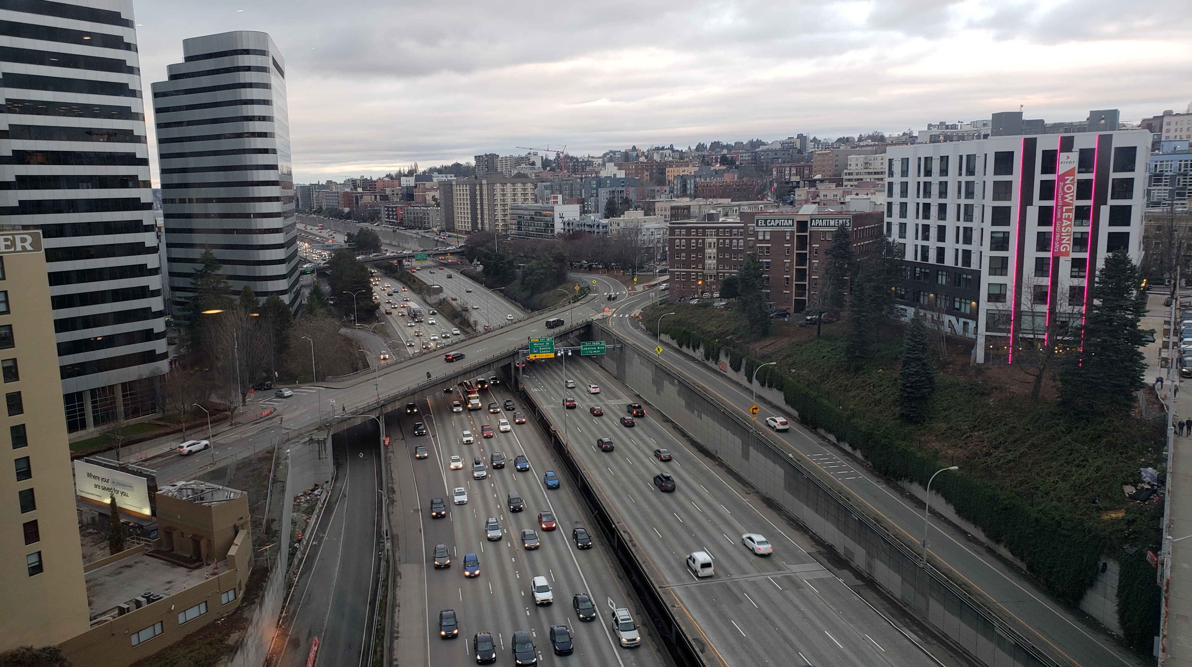
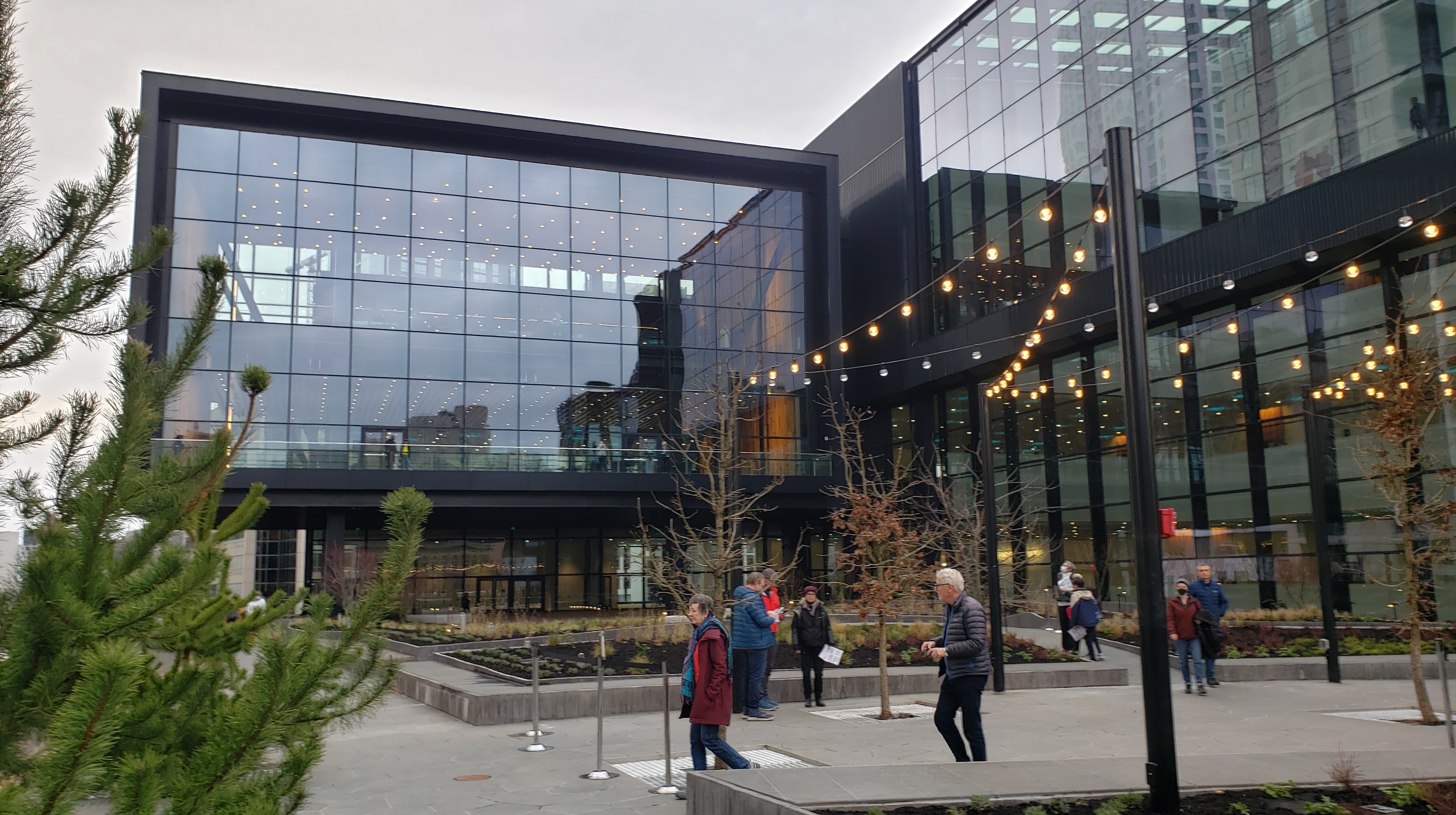
Views over I-5 and Capitol Hill from the top of the Pine Street Hillclimb inside the Summit building.Views over I-5 and Capitol Hill from the top of the Pine Street Hillclimb inside the Summit building.The new rooftop terrace on the west side of the Summit Building.
For readers interested in the story of how these benefits came to be, read on.
Project Background
The “Washington State Convention Center Addition”, as the project was formally known, began early planning around 2010. The Convention Center reported it was turning down many proposed events and needed more space to accommodate national conferences and regional meetings. Local designer David Dahl wrote several articles critiquing the project’s need, but no major public opposition to the project came up.
The public became more aware of the project in 2015 when news broke of the Convention Center’s purchase agreement for Convention Place Station, the northern portal of the Downtown Seattle Transit Tunnel (DSTT). The original reporting was a sale price of $147 million for the 4.6 acre site, but in 2017 the King County Council gave final approval for a $275 million price (nearly $1,400 per square foot). The site was essentially a giant pit and parking lot for bus layovers, surrounded by the residential and commercial skyscrapers of a growing city. The site is valuable and its redevelopment of some form was probably inevitable.
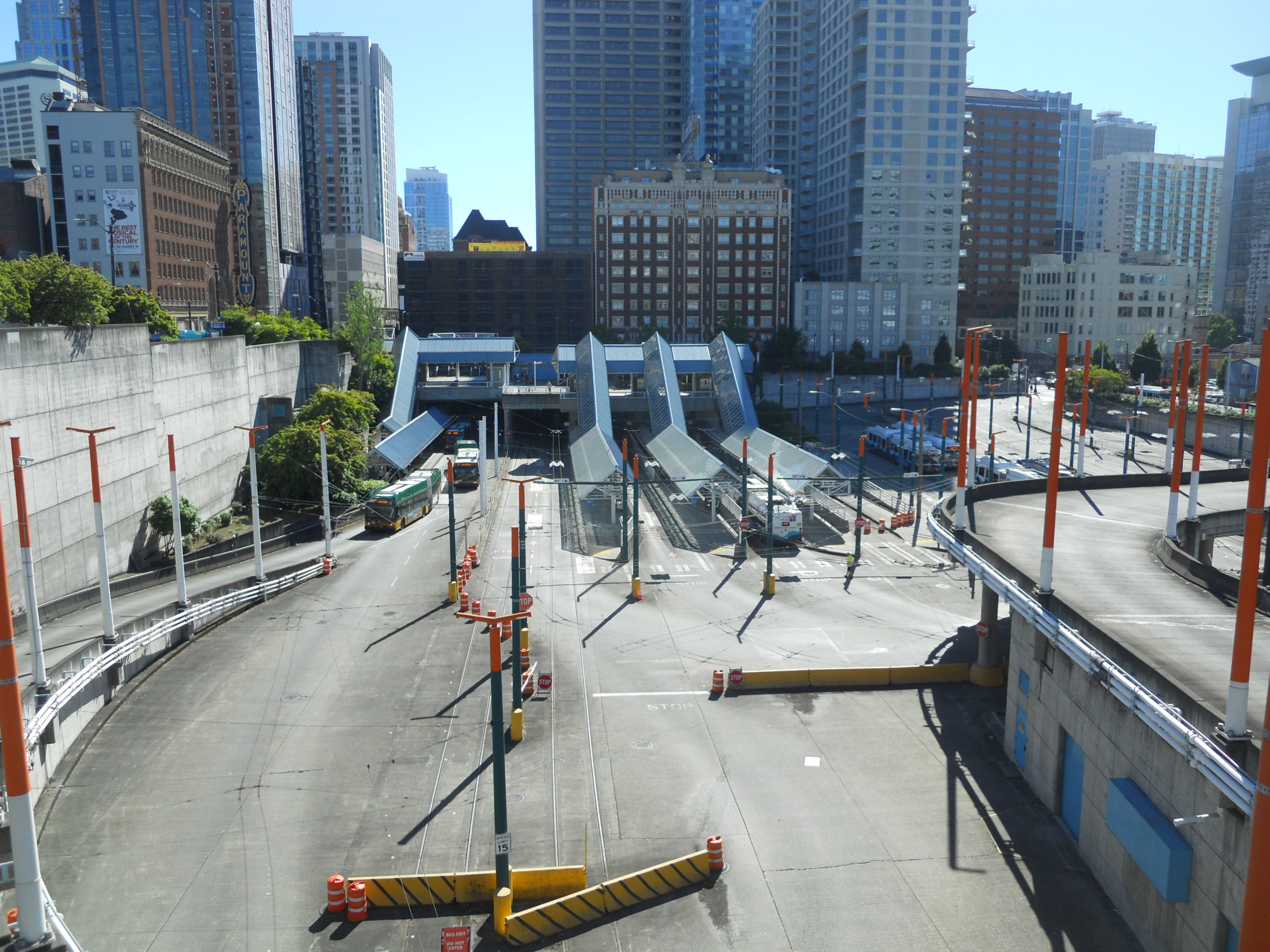
Convention Place Station in 2014, showing the passenger facility, bus parking area, and bus ramp connecting to Olive Way.
The DSTT was used only by buses from its opening in 1990, and was shared by buses and light rail starting in 2009. King County Metro intended to eventually transfer the tunnel to Sound Transit as regional light rail service became prioritized over buses. The handover was expected when light rail reached Northgate in October 2021. But the Convention Center project hastened this transition by at least two-and-a-half years, since closing Convention Place Station for construction would eliminate bus access into the tunnel. Options to keep running buses under the new Convention Center building were apparently not explored. March 23, 2019 was the last day of bus service in the tunnel and the remaining seven routes were moved to surface streets.
In addition to Convention Place, the project included two sites on the north side of Olive Way. These were to be “co-development” with an office building and a residential building, with revenues helping to pay off the main facility. The co-development also provided a unique opportunity to reduce the impacts of all the freight and truck traffic that are needed to support a major national event: The co-development would be built over a large spiraling ramp, which trucks would use to travel underground and below Olive Way to reach the new Convention Center basement.
The co-development proposal also contained liabilities: One block of a city street and two alleys sliced up the site into four small blocks. These public rights-of-way would need to be “vacated”, meaning the City of Seattle would release its interest and turn it over to the adjacent property owner. The proposed truck tunnel also required an subterranean vacation of Olive Way, and a third alley existed on part of the main Convention Place site.
The Convention Center petitioned for a total street and alley vacation of 1.28 acres, the largest ever requested in Downtown. It was also the first request for a subterranean vacation under an arterial street in Seattle.
Forming a Coalition
In most cities, the vacation process is a straightforward and transactional process. A state law dating from 1949 requires that property owners petitioning for a street vacation pay for the full appraised value of the land. Seattle is perhaps unique in having additional street vacation policy that requires “public benefits” above and beyond the value of the vacated land.
The physical impacts of the project were numerous:
The loss of Convention Place Station at least two years earlier than planned was to have ripple effects throughout the public transit network.
The loss of prime, centrally-located land that could be used for any number of other urgent public needs like affordable housing and park space
The building itself would be enormous, covering two full city blocks and having an unusual aesthetic implication for the cityscape and adjacent properties
A reconnection of Terry Avenue north of Pine Street had long been sought, but this would not be possible with the development.
Several elected officials and City staff shared that the project needed to have enough public benefits to outweigh the impacts. State Representative Frank Chopp explained his skepticism as, “We have an affordable housing crisis, not a convention center crisis” (paraphrased). The coalition was encouraged to heavily leverage the public benefits process if the project moved forward.
As the opportunity become publicized the Convention Center received many separate comments and requests for public benefits. As early as November 2015, the Seattle Design Commission (SDC) penned a letter urging the agency to consider placemaking, public art, and transportation improvements. The Convention Center decided to host an event at their own facility to air the various ideas. A smattering of community organizations were invited to an open house in December 2016, and I helped promote the event with a project rundown. In the room were people representing a range of interests: Lid I-5, First Hill Improvement Association, Capitol Hill Housing (now Community Roots Housing), Seattle Neighborhood Greenways, Freeway Park Association, and others. Each had a station with posters and staff to present their ideas. There were about a dozen public benefit ideas represented. The Convention Center later reported 500 people participated in-person and online and the Lid I-5 project was rated most favorably.
Only a few days after the event, Gordon Padelford at Seattle Neighborhood Greenways reached out to the community groups to propose a “people’s package” and to work together on a joint proposal and co-signed letter. The idea was that we would be more effective presenting a consolidated and unified voice instead of continuing to advocate independently. The Community Package Coalition quickly came together. Leading voices were Gordon, Alex Hudson then of First Hill Improvement Association, McCaela Daffern then of Capitol Hill Housing, and myself of Lid I-5. I was an unpaid volunteer with the effort, while most other participants were employees of nonprofit organizations.
Evolving Advocacy
The coalition had to work quickly, as the Convention Center Addition first presented at SDC a month later in January. The SDC assesses the merit and quality of public benefit proposals and makes a recommendation to City Council. SDOT staff are involved throughout the vacation review process and provide technical support.
There is no formula for calculating public benefits, but generally the public benefits need to be commensurate (proportional) with the scale and impacts of the proposed development. The 2+U office tower in Downtown was one of the first projects to quantify its benefits in dollar amounts. Another large scale example was a failed proposal for a Sodo sports arena.
A timely 2016 report by SDOT had reviewed over 7 million square feet of street vacations over the previous 20 years. From this, the coalition was able to asses typical or average public benefits value in proportion to the amount of vacated area. Various analysis methods resulted in an estimated value of $60-75 million for public benefits (spreadsheet here). This informed the coalition’s internal deliberations and refining a list of requested projects. Only weeks after forming, the coalition wrote and presented its first letters in front of the the SCC Board of Directors and the Design Commission.
A Community Package analysis of public benefits from midway through the process.
2017 was a busy year. The coalition launched a website and a petition, created a mailing list, mapped the proposed projects, led public walking tours, and engaged the media in press releases and a Seattle Times op-ed. There were meetings with City staff, councilmembers, and Mayor Ed Murray. Councilmember Mike O’Brien became a key Community Package champion. The coalition spoke at most of the project’s public meetings and wrote several more letters to decision-makers (see letters from March, two in May, and July).
Most significantly, the coalition hosted sit-down meetings with Convention Center agents from Pine Street Group, a well-known Seattle private development firm hired to manage the project. Most involved was firm partner Matt Griffin. There were rounds of proposals and counterproposals. The coalition was bolstered when SDOT senior advisor Beverley Barnett publicly stated that the Convention Center’s initial public benefits offer, valued at $20 million, was insufficient.
Final Approval
The coalition stuck to its guns and prevailed, but to reach an agreeable and feasible compromise several of its requests were eventually dropped for various reasons:
Construction of a one-block woonerf on Virginia Street (this was perhaps too disconnected from the project site)
Construction of a 0.3 acre Pine-Boren I-5 Lid Park (this was considered underbudgeted and risky without more engineering study)
An “I-5 Overpass Kit of Parts” to improve the pedestrian realm with art, vegetation, lighting, sound barriers, and wayfinding (artistic railings were later separately funded)
Implementing more of the Melrose Promenade (the citizen advocates were at capacity with administering a large amount of existing city and federal funding)
In October 2017, the Coalition and Pine Street Group reached an agreement and signed a term sheet (see also a press release). In November the Seattle Design Commission approved the final public benefits package. A final public benefits agreement was executed between the Convention Center and the coalition in April 2018. Next month the City Council’s transportation committee recommend approval of the street vacation and the full Council unanimously approved.
Construction took over four years. The Summit building broke ground in August 2018 and opened with a ribbon-cutting ceremony in January 2023.
Of the two co-developments between Olive Way and Howell Street, the 17-story office building at 1000 Olive Way was completed in 2024 by owner Hudson Pacific Properties. Land use permits have expired for the 29-story, 404-unit apartment building at 920 Olive Way, but public records indicate that design work is ongoing and construction may begin in the next few years.
The massive truck ramp at the base of the Washington 1000 office tower co-development.The Washington 1000 office tower, and in the foreground is the site for the future apartment building co-development.
Conclusion
Not every development has an opening into negotiations like a street or alley vacation, but advocates have many other tools at their disposal and should utilize the power of their elected representatives. The Community Package was one form of a “community benefits agreement” that some developers enter into voluntarily or which some municipalities require for certain projects. Development agreements, zoning bonuses and incentive zoning, funding conditions, and other creative methods may be available depending on where a project is located.
A collaborative process resulted in a successful $62 million Community Package that today is fulfilling its promises for current and future generations of Seattleites. The project should be a model for other engagements between leaders of major developments and everyday community members who need great spaces to play, safe streets to travel on, and affordable places to live.
In early January I was hit by a car in West Seattle while biking home. Thankfully, the collision was minor and I got away with no physical injuries. The car may have fared worse with a scratch and a dangling mirror. In the interest of preventing anyone else from getting hurt at a key intersection, I am telling the story of what happened and what I think can be done to prevent it from repeating.
This is a multi-part series. See the others here: Part 1 and Part 2.
Copenhagen
This slideshow requires JavaScript.
In Part 2, I shared the comical travails of getting from Berlin to Copenhagen. After a stopover in Hamburg, the story continues.
On my last train of the day, I met a German woman named named Christina who lives in Norway. She was a hospital worker, and was returning home and cutting short a holiday to Germany because of the coronavirus. The train ride was also interesting because at one point it crosses over the 10-mile wide Great Belt, a strait that separates the western half of Denmark from the island of Zealand, the country’s most populous region and the home of Copenhagen. Trains cross half the Great Belt on a bridge, and the other half in a tunnel. Prior to this link’s completion in 1998, only ferries crossed this area. Passenger trains would be loaded onto those ferries back in the day.
This is a multi-part series. See the others here: Part 1 and Part 3.
Brussels
This slideshow requires JavaScript.
I knew next to nothing about Brussels, apart from the fact that is the capital of Belgium, where a friend of mine is from. Upon arrival I discovered that most public signage is in Dutch, which is much harder to muddle through than French. But I was able to eventually make a connection to the local streetcar system and get to my next hostel. Along the way I noted the mix of architectural styles and seemingly random building heights.
One year ago today I woke up at 3am and boarded a plane at Stockholm Arlanda Airport, reluctantly evacuating myself from the closing jaws of European borders. I was just 15 days into a planned 30-day continental tour, the adventure of a lifetime, when a terribly timed pandemic cut the trip short. As we hit the one-year mark of the COVID-19 era, I finally feel up to writing about my trip and casual observations on European urban design and planning.
There’s a lot to share, so I’m breaking this post into several parts. This is Part 1, which goes through the first six days of the adventure including London, Paris, Normandy, and Brussels. Part 2 will take us to my five days in Berlin, Amsterdam, and Hamburg. Part 3 ends with the final four days in Copenhagen, Oslo, Stockholm, and my return trip home.
This episode of CascadiaCast is with Laura Goodfellow. A runner since middle school, she started combining her workouts with transit routes when she moved to Seattle and took advantage of citywide and regional connections. With marathon training, most of her runs are six to eight miles but often reach into double digits. She has started attending Seattle’s pedestrian and transit advisory board meetings to get the inside scoop on local projects.
“What makes it fun is I don’t have to take long, expensive vacations to faraway places because a weekend feels like a mini-vacation,” Laura says. “I go on this running adventure to Vashon Island, to Bainbridge, or to Gig Harbor.”
We talk about the urban marathon circuit, pedestrian safety, the state of Seattle transit, King County’s new Trailhead Direct service, and multimodal funding constraints. While it’s easy to get lost in project details, Laura says, “What’s important to me is pushing the shift of seeing transit as desirable.” For example, “To get from a meetup, people would offer me a ride home…they thought, ‘that poor girl, she has to ride the bus home’. I know it’s very generous of them, it comes from a place of kindness. But it also reflects that our society sees transit as an undesirable last resort.”
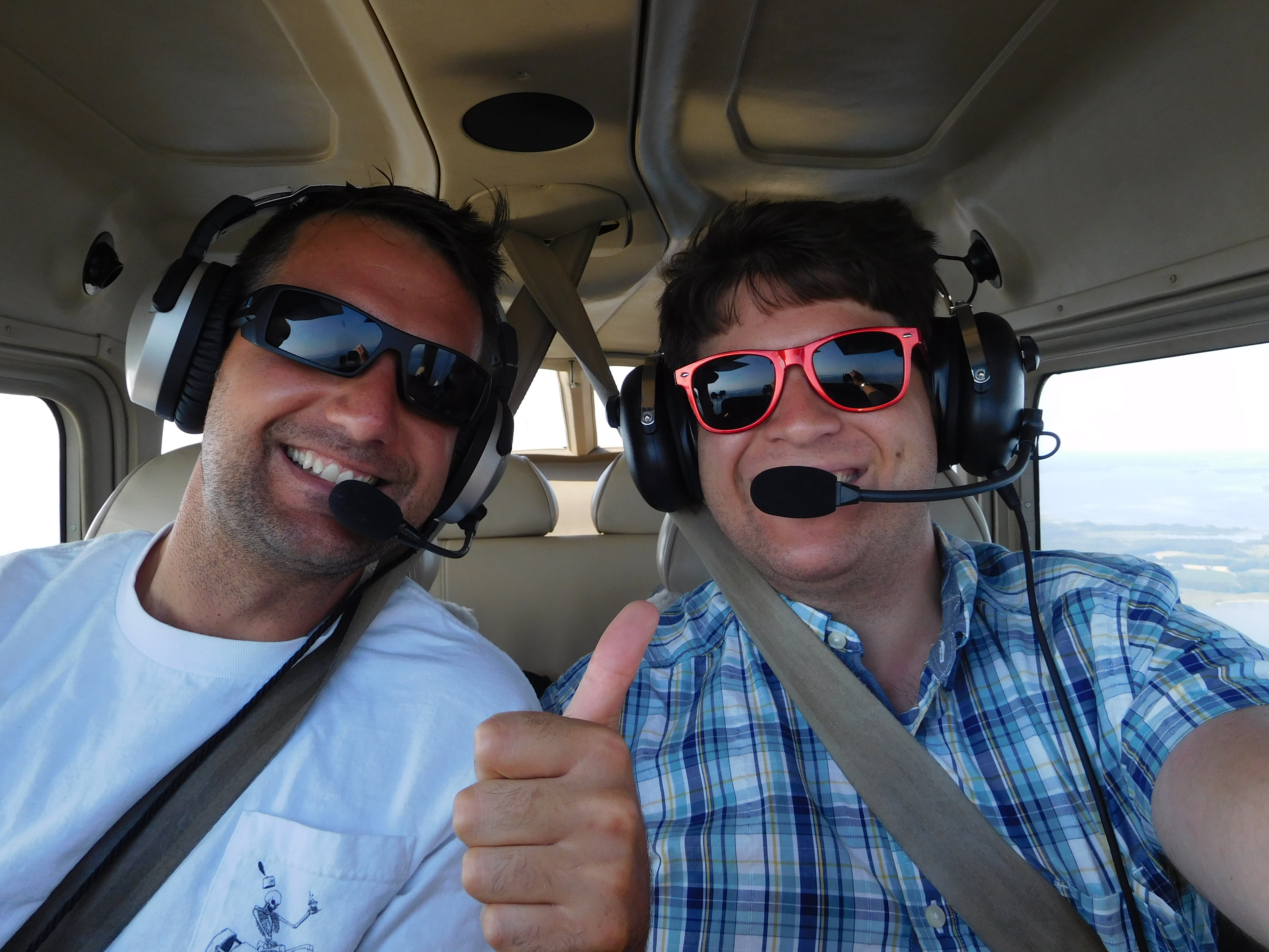
This episode of CascadiaCast is uniquely co-hosted with Hunter Bevis, my older brother and producer of the aviation podcast Time In Flight. By coincidence, for both of our podcasts this is episode eight!
Hunter spent his formative years in North Bend, Washington and now resides in Pasadena, Maryland. He recently made a career change from consulting to flight instructing. We both recently acquired our commercial drone pilot licenses, leading to a great discussion on why I chose this route to expand my skill set. We also talk about recent changes in the unmanned aircraft industry and the regulatory environment. We cover drone applications for urban planning, potential safety and sky clutter impacts as drones become more widespread, and the relationship with manned aircraft.
We also touch on my own passion project of lidding I-5 and Hunter’s perspective on how rapidly cities are changing and facing affordability crises.
Visit the Time in Flightwebsite and Instagram page for more on the world of aviation and Hunter’s daily adventures of in the life of a flight instructor.
“Buy land, they’re not making it anymore.” – Mark Twain
As Seattle’s development boom continues without any sign of stopping, the city is rapidly approaching a point where Downtown is completely built out and there is no land left to build on. In many ways this is a desirable situation. Urban density has clearly documented benefits for environmental sustainability, economic vitality, and public health. However, as Downtown sees more jobs and residents arrive, decades of sluggish planning are catching up and exposing voids in important public infrastructure and services. Downtown’s housing stock grew 127 percent between 1996 and 2015, now totaling over 24,000 homes, but residents have not been supported by parallel growth rates in capital facilities like schools and parks.
Downtown – and more broadly the Center City – is the thriving cultural and economic hub of the region. It encompasses and borders a variety of high-density, mixed-income, and diverse residential neighborhoods like the International District, First Hill, and Belltown. It is home to important institutions, entertainment venues, and social services used by people from across the region and state. Because Downtown affects the health and success of so many people and places it must become a more complete neighborhood.
I am often met with awestruck wonder when people learn I don’t have a car. After all, driving everywhere is the American way. There are too many explanations to keep a good party conversation going, so it boils down to cost and abundance of transportation options. But I don’t get too far before I’m assured I’ll buy a car eventually or I’m declared to be a quixotic car-hating lunatic.
Have you been looking for a way to get directly involved with the Lid I-5 movement? Now is your chance!
Join us on Saturday, September 16, for a design charrette focused on the segment of Interstate 5 dividing Wallingford and the University District. At this free public event we’ll build a vision for reconnecting these two neighborhoods which have been divided by the Interstate 5 freeway for more than half a century.
Community ideas–that is, your ideas–are needed to help broaden the conversation and build public support for this important campaign. Pedestrian links and lids for parks and affordable housing are expected to be popular concepts in a rapidly growing area that recently underwent a major upzone and is expecting a new light rail station in 2021.
The event will include a brief presentation on the origins and goals of the Lid I-5 community effort, along with a summary of two previous charrettes focused in the downtown area. Participants will be divided into small teams to identify problems caused by the freeway and develop design solutions.