According to the Merriam-Webster Dictionary, equity in a social sense means “freedom from disparities in the way people of different races, genders, etc. are treated”, and often more specifically referring to “freedom from disparities in the way people of different races, genders, etc. are treated.”
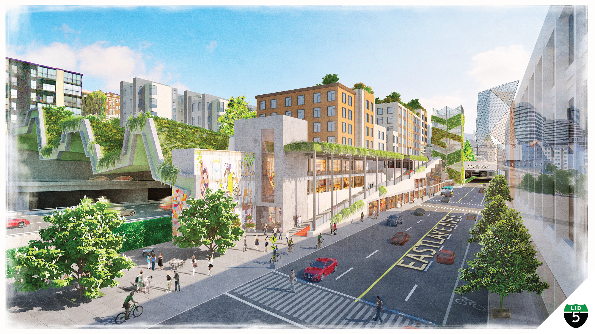
Socioeconomic and geographic equity is a key consideration in the work of the volunteer-based Lid I-5 Seattle campaign. The core purpose of the urban freeway lid concept is to expand public land and reduce the environmental harms of high-volume traffic in the middle of densely populated neighborhoods. Freeway lids require significant public resources to achieve, so asking whether such a lid project is an equitable endeavor is a natural and important question.
Unfortunately, that question was rarely asked about the original freeways themselves in the early years of the American experiment with the interstate program. The 48,000 mile system was largely scoped, planned, and under construction starting in the 1950’s, well before keystone legislation like the 1964 Civil Rights Act and the 1970 Environmental Protection Act. These laws started to require major public works to conduct meaningful public engagement and offer community mitigation measures, though still did not fully prevent the worst impacts. Freeway widenings and extensions continue today, even as the science finds that larger roads bring more traffic and harmful pollution.
Still, equity has emerged as an important value among urban planners and elected leaders. Amid Seattle’s decades-long affordable housing and homelessness challenges, transit expansion aspirations, large gaps in the sidewalk network, and other infrastructure needs, where do freeway lids sit in the priorities for public spending?
According the Seattle Office of Community Planning and Development’s Downtown-area 2020 I-5 Feasibility Study for the Downtown area:
“The lid could provide affordable space to marginalized communities in an area with the highest access to opportunities. Equity is a major priority for Seattle, and with escalating rents, displacement is pushing out the most vulnerable people and businesses from urban neighborhoods. The lid could create physical space and catalyze investment in communities that have been disenfranchised to improve outcomes for populations that have been hardest hit by historical disinvestment, displacement and gentrification.”
To dive deeper, this article provides research findings on several aspects of socioeconomic and geographic equity with the help of Census data, historic documentation, and academic research. The findings suggest that lidding I-5 in Seattle – at least starting with the Downtown-area neighborhoods – will clearly result in widespread, equitable public benefit and quality-of-life outcomes.
Who Benefits
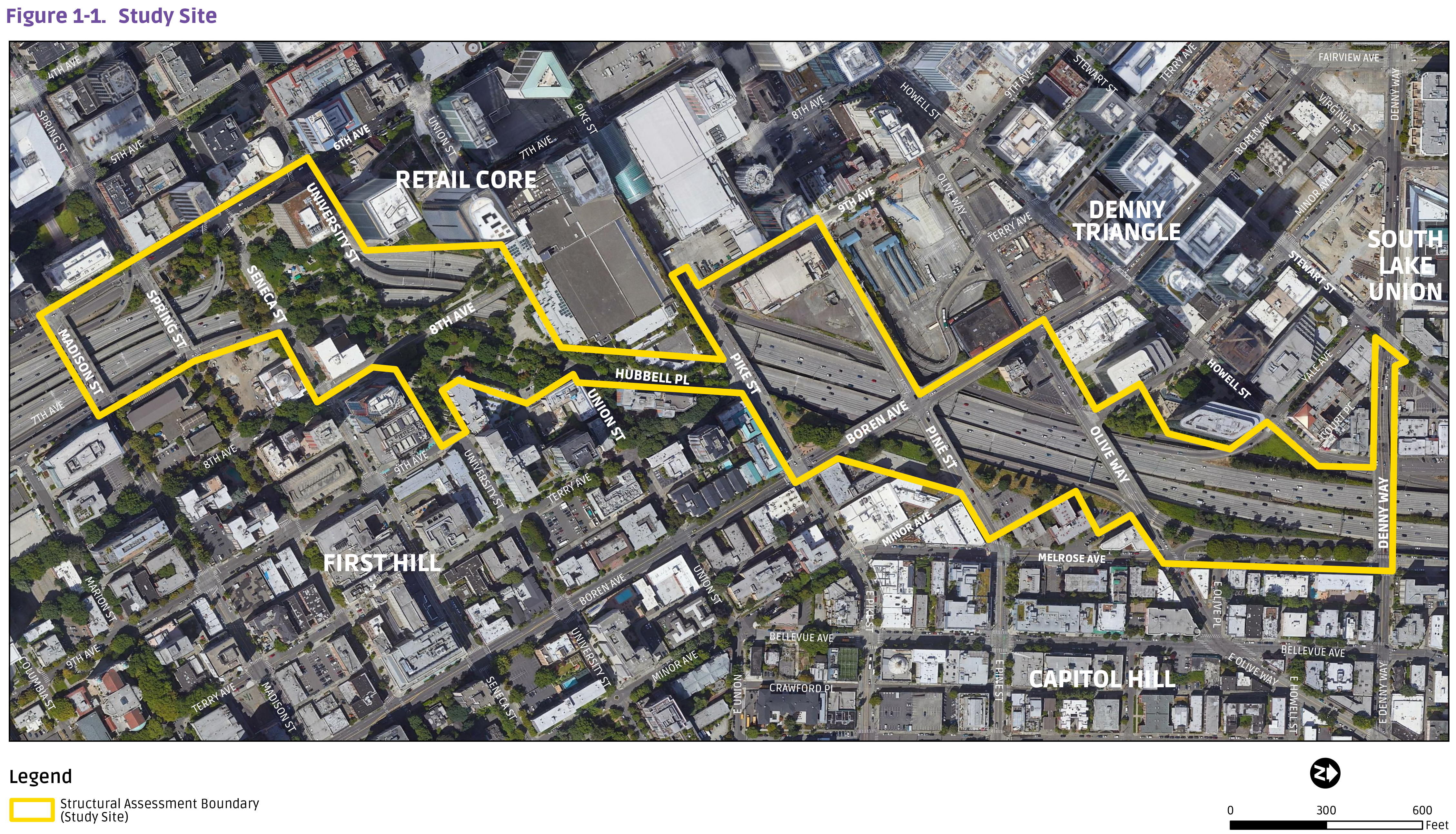
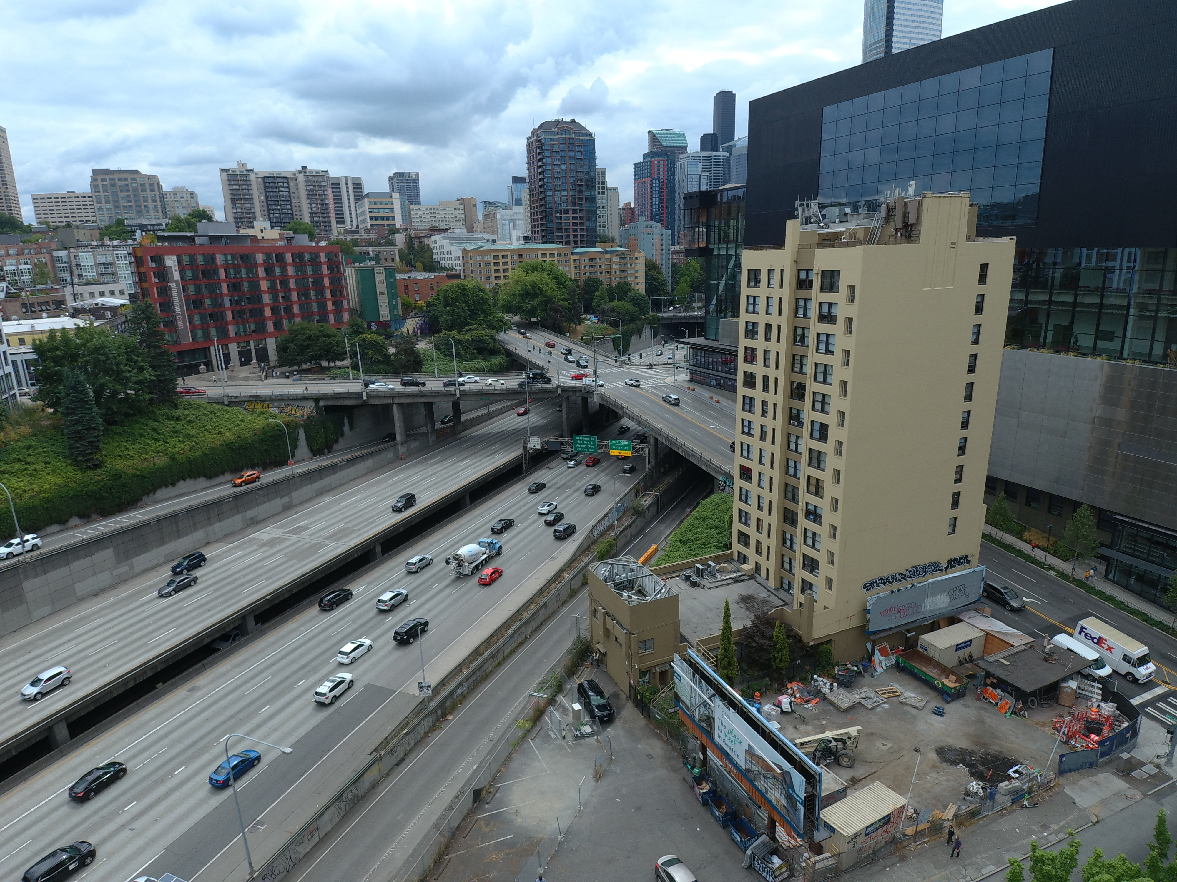
The 2020 I-5 Lid Feasibility Study found that the neighborhoods of Downtown, Capitol Hill, First Hill, and Denny Triangle are home to a broad mix of people including many low-income families, people of color, and children.
When I-5 was built through Downtown, it went through redlined neighborhoods that were designated by banks and mortgage companies as “hazardous” and “definitely declining”. This practice discouraged residential and commercial investment and was targeted against “Native people”, “Orientals”, “Negroes”, and other minorities. This continued until it was prohibited by state law, yet the study area has not fully recovered from this racist policy and still has a concentration of some of the city’s lowest income residents with very low access to parks. The area is dominated by rental housing and has few homeownership opportunities for building intergenerational wealth.
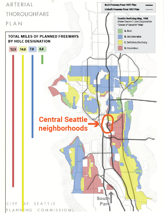
Today, the formerly redlined neighborhoods are more racially and economically diverse than the Seattle population as whole. The United States Census, as of 2021, estimates that 62,565 people live within walking distance of I-5 in the Downtown study area, which consists of mapped census tracts within 1⁄4 mile of the freeway right-of-way. Of those people:
- 54% of residents are people of color (vs. 39% citywide)
- 88% of households are renters (vs. 54% citywide)
- 49% live in households that do not own a vehicle (vs. 17% citywide)
- 15% live in poverty (vs. 10% citywide)
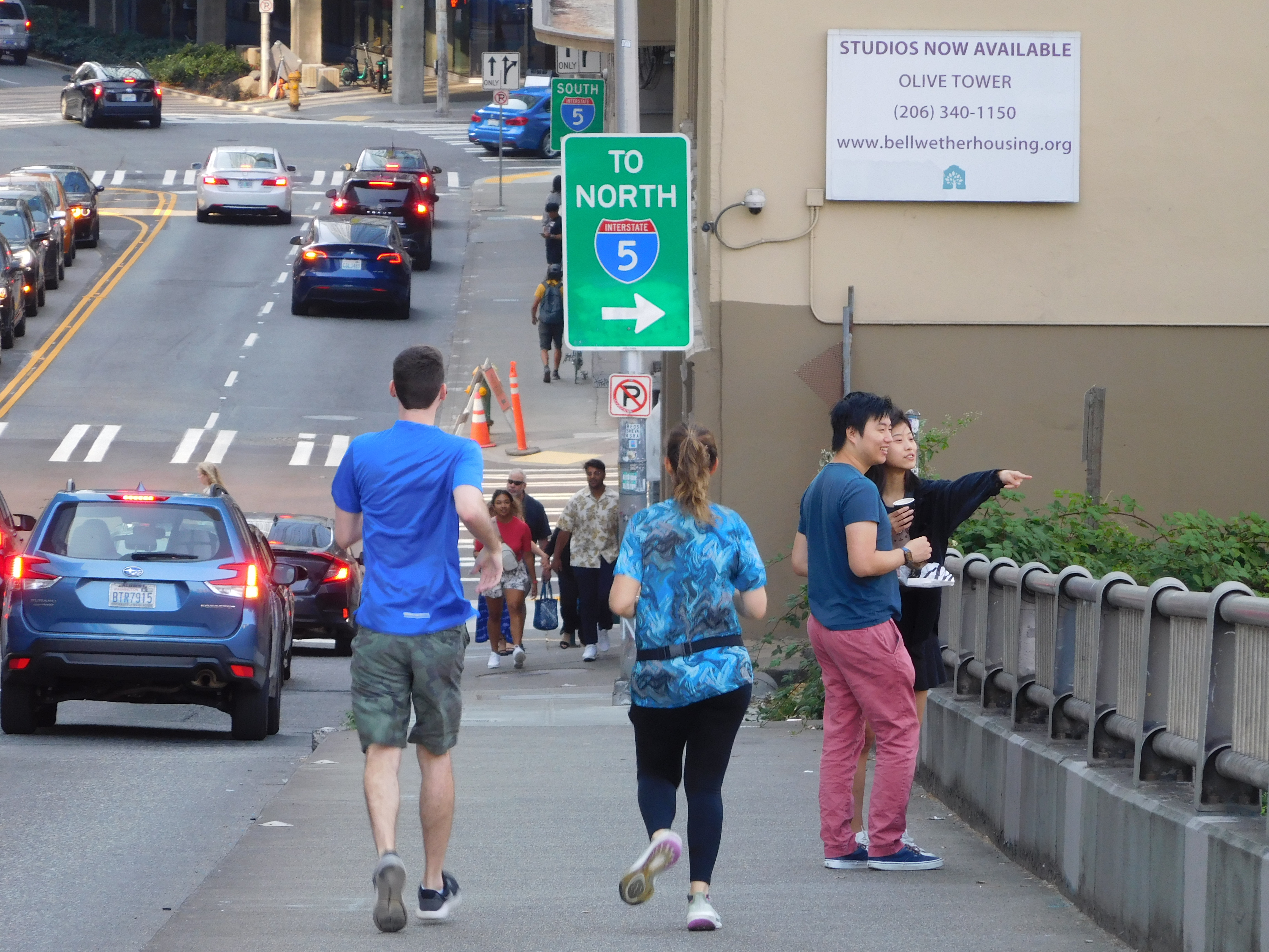
Further, the average median household income in these census tracts is $84,760, which is 20% lower than the Seattle citywide median income of $105,391. Throughout the study area there is a concentration of low-income housing, with over 6,000 public, subsidized, and other income-restricted homes. At least 1,000 of these low-income households live within one block of Interstate 5 (e.g., see property maps for Seattle Housing Authority, Bellwether Housing, Community Roots Housing, Plymouth Housing, and the Low Income Housing Institute). Yesler Terrace, the nation’s first interracial public housing development, had 11 acres demolished when Interstate 5 was constructed, but still remains the city’s largest mixed-use affordable housing neighborhood.
The study area is also four times as densely populated as Seattle as a whole – but doesn’t necessarily have four times the access to essential amenities for urban living. According to City of Seattle data, the neighborhoods of Downtown, Capitol Hill, and First Hill are 3.5 percent of Seattle’s land area but have been absorbing 29 percent of population growth. This is occurring without commensurate investments in public infrastructure, such as schools, parks, and community centers. With vacant and re-developable properties becoming scarce, lidding I-5 is likely the only opportunity to catch up on much-needed park space, affordable housing sites, and civic functions like schools and recreation facilities (see more analysis on Downtown public land).
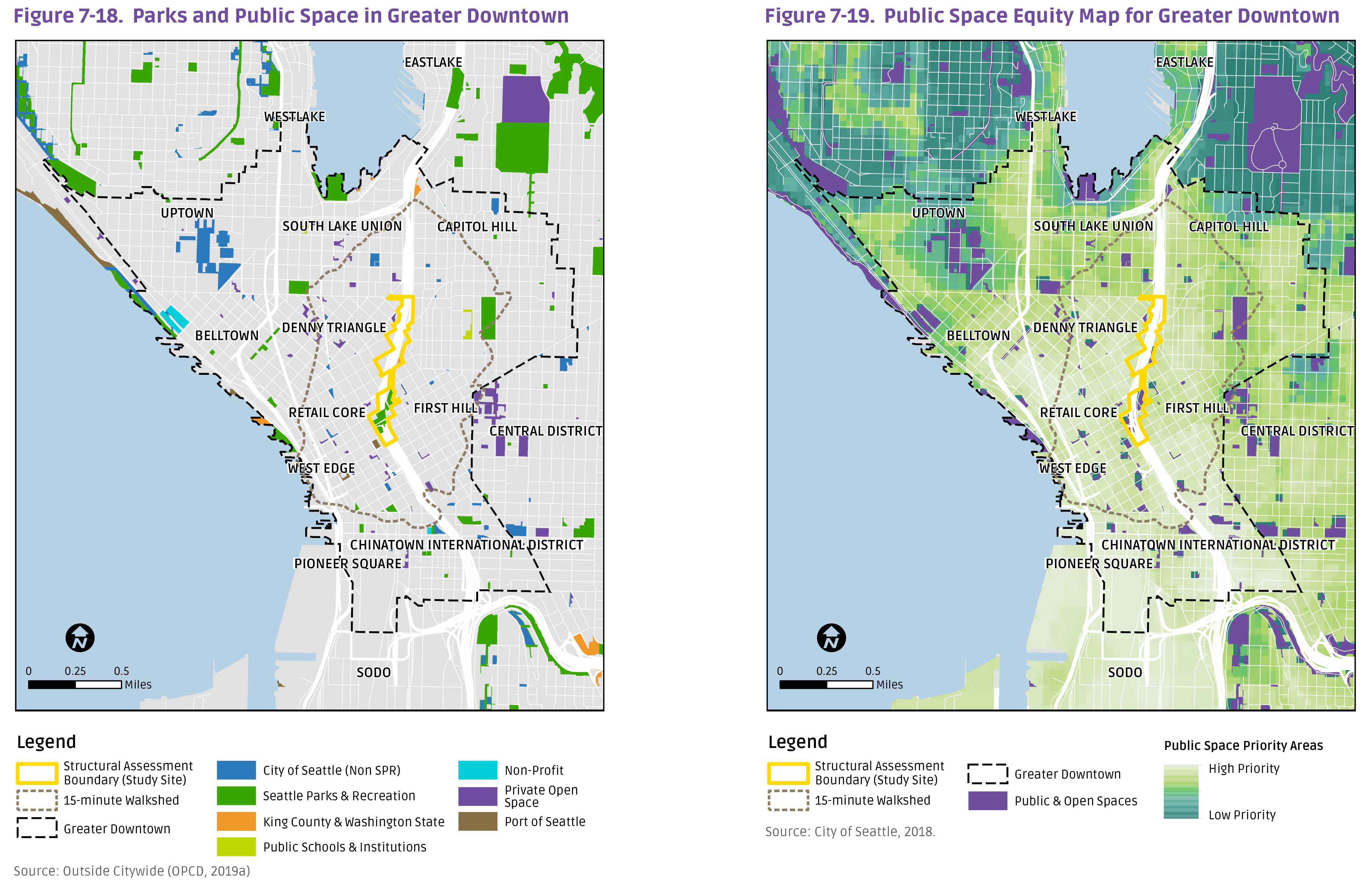
Additional evidence of the equitable project location is the “economically disadvantaged communities” criteria being met for a federal Neighborhood Access & Equity grant awarded to the City of Seattle for lid planning. It was determined that 89% of the census tracts in the study area economically disadvantaged under multiple metrics such as USDOT Historically Disadvantaged Communities, Inflation Reduction Act Disadvantaged Communities, the Washington Department of Health environmental health disparities map, and the City of Seattle Racial and Social Equity Composite Index which shows the study area includes census tracts identified as “Highest” and “Second Highest” priorities for achieving greater equity in planning and investment. The federal government agreed the criteria was met and waived the requirement for a 20% local match to grant funding.
The demographic data shows that lidding I-5 will benefit a diverse cross-section of community members and families representing a variety of racial and ethnic identities and socioeconomic status, all living together in the city’s most densely populated neighborhoods. The 2020 Lid Feasibility Study concluded:
“All aspects of future work to realize a lid will present critical opportunities to advance racial equity—from the governance model, who partakes in the decision-making process, to the project delivery mechanism . . . [the lid] presents an opportunity to tackle some of the most pressing challenges facing Seattle . . . to increase affordable housing, support and protect local industries and small businesses, and make vital investments in infrastructure, community facilities and open space . . . [while] the robust fiscal and economic benefits of a lid, in addition to the public benefits described in this study, make a lid project worthy of consideration . . .”
Balancing Regional Investments
King County is home to more freeway lids than any other metropolitan area in the United States (though Boston may soon overtake). Compared to Seattle’s lids, other freeway lids in the region mostly exist in low-density neighborhoods with a high proportion of White and affluent households. Equity must also be assessed within this broader geographic context because Interstate 5 is part of a regional transportation system, it is managed by a statewide transportation department, and the federal government historically funded it and today regulates it.
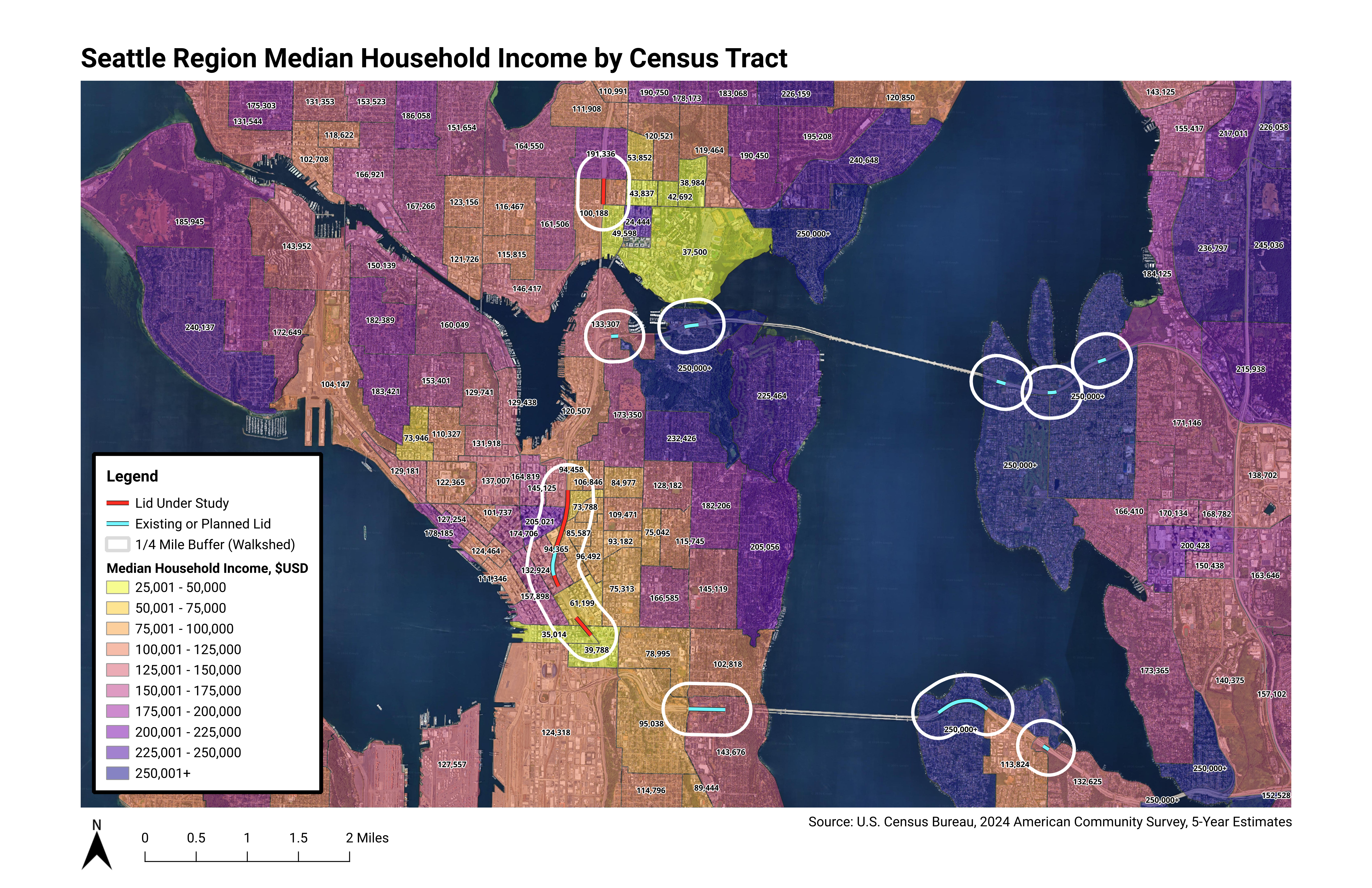
The map above shows the variation in incomes between central Seattle and outlying neighborhoods and suburbs. Aubrey Davis Park on Mercer Island, for example, is a large, half-mile long park offering active and passive recreation. But its location mostly benefits single-family homeowners with median incomes over $250,000 (Census data does not report specific amounts above $250,000). And, notably, the park is offset from the Mercer Island town center, which has multiple apartment buildings and now a light rail station. The recent lid parks over State Route 520 are also enjoyed by residents with high incomes.
This may be compared to the Seattle study area, where 15 percent of residents live in poverty and median incomes are as low as $73,000 – and incomes are even lower in Yesler Terrace and Chinatown-International District, which face the most severe challenges for connectivity and health around the freeway. Income and wealth is known to be tied to race.
Academic research provides further evidence of disparities. A 2018 study by Douglas Houston and Michelle E. Zuñiga at the University of California, Irvine, titled “Put a park on it: How freeway caps are reconnecting and greening divided cities”, analyzed the environmental justice impacts of many freeway lid parks across the country.
Considering poverty rates and rates of people of color living near the parks, and comparing those rates to wider metropolitan regions, the researchers built a parity index to assess whether freeway lids have been equitably located.
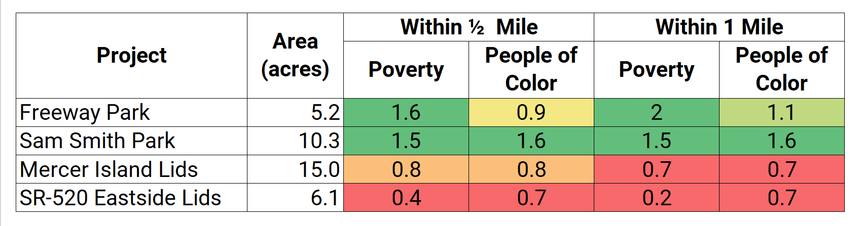
In the table above, a score less than 1.0 (red) indicates the rates of poverty and racial and ethnic identifies are lower than the metro region, and a score more than 1.0 (green) indicates the rates are higher. In other words, the larger the value, the more equitably the lid park is located. The study found the local freeway lids inside Seattle (Freeway Park and Sam Smith Park) are more equitably located than the suburban lids built outside Seattle.
Public Health
The nation’s transportation system has long been built upon inequities. According to the American Planning Association’s Healthy Communities Policy Guide:
“Layered upon one another, policies for housing, transportation, and development have been vehicles for institutional discrimination, leading to significant health inequities. Historically, these decisions are linked to some of the nation’s most intractable public health problems, including adult and childhood obesity, substance abuse, cancer, respiratory problems, and environmental injustices. Addressing these health challenges requires that we integrate public health with planning for the built environment. It also requires an explicit focus on health inequities.”
For example, car commuters, on average, have much higher incomes than those who commute by transit, bicycling, or walking. This causes a considerable environmental injustice. City dwellers who live in dense housing near freeways and who are more likely walk, bike, and ride transit are more prone to freeway traffic’s harmful air and noise pollution. In the Seattle study area, this is an especially inequitable situation for low-income people living within a block or two of I-5.
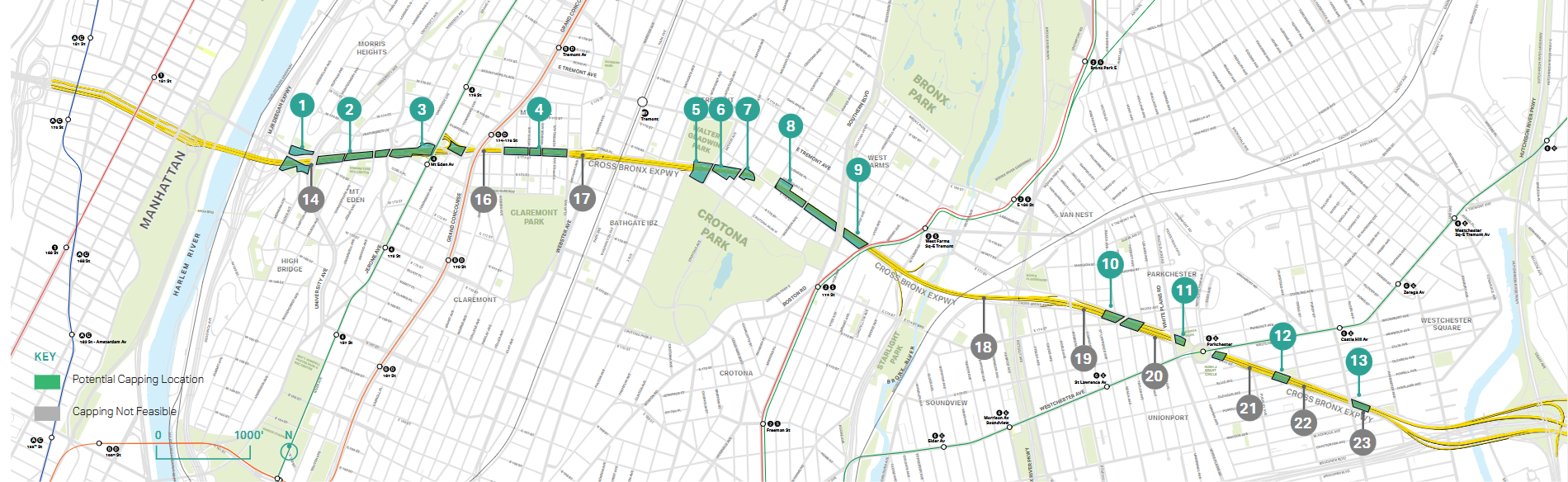
A 2017 public health study from Columbia University provides a case study for the equitable public health benefits of freeway lids. Researchers modeled a concept for a series of lids over portions of the 6.5 mile Cross-Bronx Expressway in New York City. A large share of the City’s minority population lives in the Bronx borough. The study found a net positive value of over $1,600 per capita, measured through increased property values, lower medical costs, and an extra two months of quality-adjusted life years (a measure of health and lifespan). Improved health came from reduced pedestrian-vehicle interactions, lower air and noise pollution, and more opportunities for people to exercise. These gains more than make up for the modeled $757 million capital cost.
Peter Muennig, MD, MPH, a professor of Health Policy and Management at Columbia’s Mailman School and senior author on the study, elaborated on the many benefits of lid parks:
“It is extremely rare for social policy investments to save both money and lives…Examples include vaccines and basic automobile safety measures like seatbelts. Turning a highway into a park is a bit [like] a seatbelt or vaccine for a whole neighborhood.”
A community proposal for capping the Cross-Bronx gained momentum in 2021 with a $2 million federal RAISE grant. In 2025 the New York City Planning Department released a vision study that proposes short, mid, and long-term improvements for the neighborhood, including many acres of caps along with other transportation improvements. Governor Kathy Hochul committed to providing funding a Planning and Environmental Linkage study to advance the project.
Removal vs. Lidding
If urban freeways have such negative impacts on public health and the environment, perhaps removing them entirely would be the better solution. Local advocacy organizations like The Urbanist have suggested this for the central part of I-5, and the idea was further explored in a report at The Stranger.
The interconnected nature of modern infrastructure systems makes this a complex proposition. The Seattle portion of I-5 supports regional and national freight movements which are essential to Washington’s industries. Cargo trucks move containers between ports and warehouses, deliver food to grocery stores, and supply every other type businesses. I-5 also serves more utilitarian duties like mail delivery, garbage pickup, and disaster response. And as more people move to suburban communities, especially low-income families who are facing high housing costs, I-5 and other freeways provide an important link to Seattle’s job, education, and healthcare opportunities.
Average traffic on I-5 through Downtown is over 200,000 vehicles per weekday. Comparatively, on the Alaskan Way Viaduct was only carrying about 80,000 vehicles before it was closed in 2019, and the replacement tunnel, which is tolled, carries only about half of what the Viaduct did – meaning some amount of north-south regional traffic likely shifted to I-5. Interstate 5 is also a major route for intercity bus service operated by Metro, Sound Transit, and private companies.
This type of bittersweet dynamic was noted by Keith Baker, executive director of ReConnect Rondo in St. Paul, where Minnesota’s most vibrant African American neighborhood was decimated by a freeway:
Baker says that he’s not opposed to filling in the highway, but it’s probably not realistic given I-94’s status as Minnesota’s most-used freeway, carrying more than 150,000 cars a day.“To just decide to fill it would require first fully appreciating the impacts on the Black community itself,” Baker adds. “The community does get resources through this incredibly important vein.”
It is feasible to remove downtown freeways in many situations, such as low-traffic segments, duplicative routes, and stubs. These are often last-mile connections and could better serve urban neighborhoods as regular surface streets. Examples abound nationwide: I-705 in Tacoma, I-405 in Portland, I-375 and I-175 in Tampa, I-375 in Detroit, I-83 in Baltimore, I-280 in San Francisco, I-980 in Oakland (see the Connect Oakland project), and I-45 in Houston (partial removal is already planned). The Congress for the New Urbanism maintains a list of such “freeways without futures”.
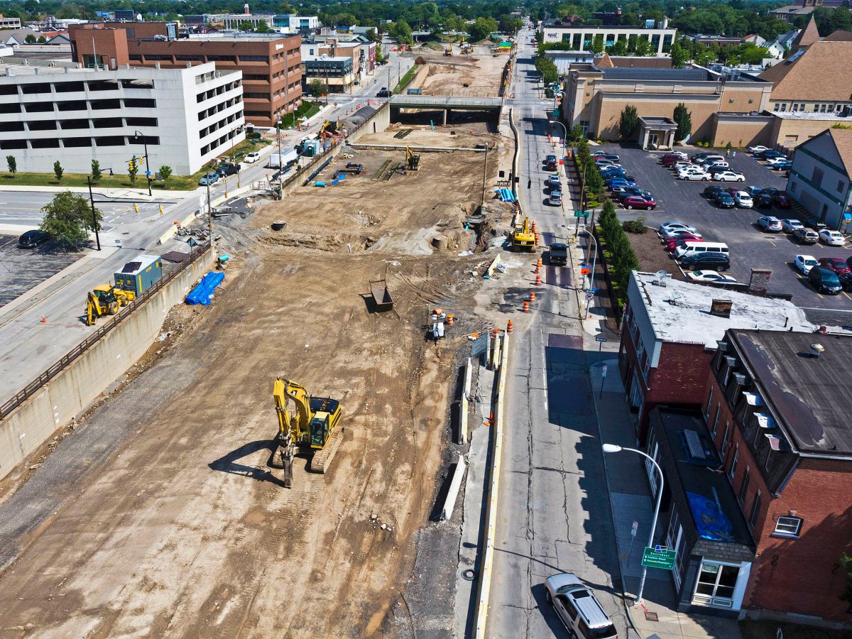
Rochester, New York is in the process of removing a relatively small 4-6 lane freeway loop in its center city, replacing the land with city streets and sites for private development.
For Seattle’s portion of State Route 99, there are related grassroots efforts for Aurora Avenue Reimagined in the north and a vision to Reconnect South Park in the south.
Beyond the Lid I-5 campaign, further steps are needed to rebalance the transportation system for sustainability and affordability. Among the many possible strategies are more continuous carpool and bus lanes, peak-hour decongestion tolling, greater investments in frequent transit service, and zoning reform to allow more people to live close to jobs, schools, and services.
The Interstate System
While the origins of the interstate freeway system ostensibly lie in national defense, discriminatory economic and social forces were also in play. Throughout the 1950s and 60s, and even through today, many urban freeways have been intentionally routed through poor and minority neighborhoods where land was cheaper and political capital was limited. In The Color of Law, author Richard Rothstein documents how government leaders and industry groups used the arguments of slum clearance and racial separation to advocate for freeways in urban centers. Early freeways supported an exodus of affluent and White households from America’s city centers, leaving the remaining neighborhoods split apart for the convenience of suburban commuters.
Unlike in many U.S. cities, the impacts from the development of Interstate 5 did not fall heaviest on Seattle’s communities of color. Approximately 4,500 properties were demolished and 40,000 residents were displaced by Interstate 5’s construction, the largest relocation of households through eminent domain in the Seattle’s history. Historic Census maps compiled by the University of Washington’s Seattle Civil Rights & Labor History Project show that the majority of these impacts fell on majority-White neighborhoods made up of detached single-family homes, though many commercial and multifamily buildings were also demolished.
This outcome was also observed by the thesis research of Alberta Bleck at the University of California, Berkeley, who found African American residents not disproportionately displaced from their homes by the construction of Interstate 5. Bleck confirms the most egregious racial disparity in Seattle was the splitting of the Chinatown-International District. Demolition in that neighborhood affected multiple Japanese-owned businesses and community services. In industrial South Seattle, where much of Seattle’s Asian population has resided, the development of I-5 reduced the useable size of the Cleveland High School track and the Georgetown Playfield, the only park property impacted by the freeway.
The City of Seattle requested a rail transit facility to be integrated into the freeway, which could have promoted greater accessibility to the freeway’s benefits. This was rejected by the Washington State Highway Commission, along with unsuccessful proposals to include lids in the original freeway design. In the same vein, Bleck finds that as time went on following freeway construction, “Seattle’s segregation patterns persisted and deepened, now with I-5’s walls and roaring traffic serving as a physical barrier eliminating inter-neighborhood mobility and integration.”
I-5: A Warning for Seattle
Freeways were a new type of transportation system at the time and it was difficult to foresee how they would interact with established communities. When I-5 opened in 1967, after years of demolition and construction, the greater threat of freeways to Seattle became obvious. Residents could see for themselves that freeways facilitate efficient regional connections, but at the local cost of neighborhood connectivity, peace and quiet, clean air, and traffic.
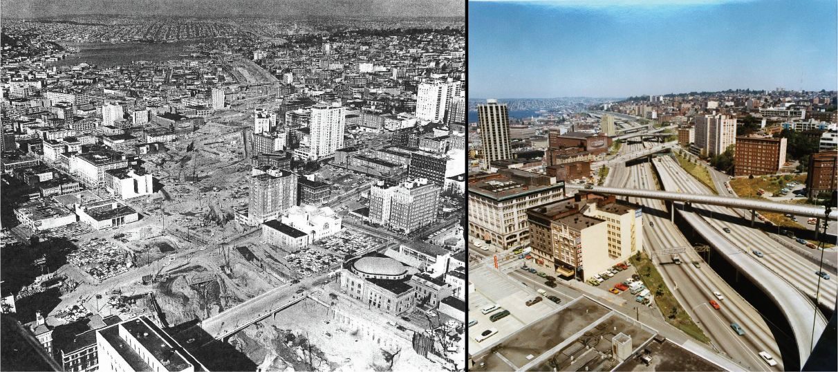
During and after I-5 was built, a parallel freeway a mile east was planned by the state. The R.H. Thomson Expressway would have ripped through the Washington Arboretum and split apart the Central Area, the center of Seattle’s African American population (largely concentrated there as a result of redlining practices). The R.H. Thomson project would have displaced 4,000 residents and many businesses.
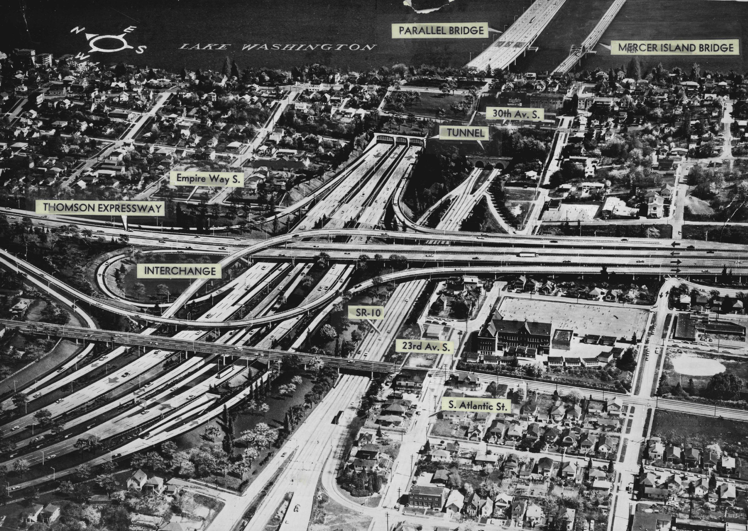
Soon after, in 1968, Citizens Against R. H. Thomson and Citizens Against Freeways formed strong and vocal coalitions against Seattle’s next projects. Groups involved were as varied as the Central Seattle Community Council, Allied Arts, Black Panthers, League of Women Voters, Washington Environmental Council, and the Legal Services Center.
Their efforts worked. In 1970 the City Council cut off funding for the Expressway, though it wasn’t until a 1972 public referendum vote that the project was officially terminated. That year voters also rejected the Bay Freeway, a viaduct that would have followed Mercer Street in South Lake Union. Across the United States, the “freeway revolts” and citizen action led to a number of other freeway project cancellations.
The group Seattle ARCH (activists remembered, celebrated, and honored) is preserving the legacy of these efforts by documenting the work and leading efforts for a memorial. See Seattle’s Freeway Revolt: A Directory of Historical Resources at the Seattle Public Library, a thorough compendium produced with 4Culture and Shunpike.
In the years that followed, the Mount Baker neighborhood was similarly inspired. When planning to expand and rebuild Interstate 90 in the 1970’s, the Mt. Baker Community Club’s representative on the mayor’s I-90 Citizen Design Advisory Committee insisted that I-90 enter Seattle through a new Mt. Baker Ridge tunnel. This was adopted in the official plans, and later other citizens lobbied WSDOT to also build a large lid, later named Sam Smith Park after the first African American resident to serve as a Seattle city councilmember. This began setting the precedent for other freeway mitigation projects in the region, including five landscaped lids over the rebuilt SR-520 and ideas for lid park in Downtown Bellevue over I-405 (since reduced in scope to a pedestrian bridge).
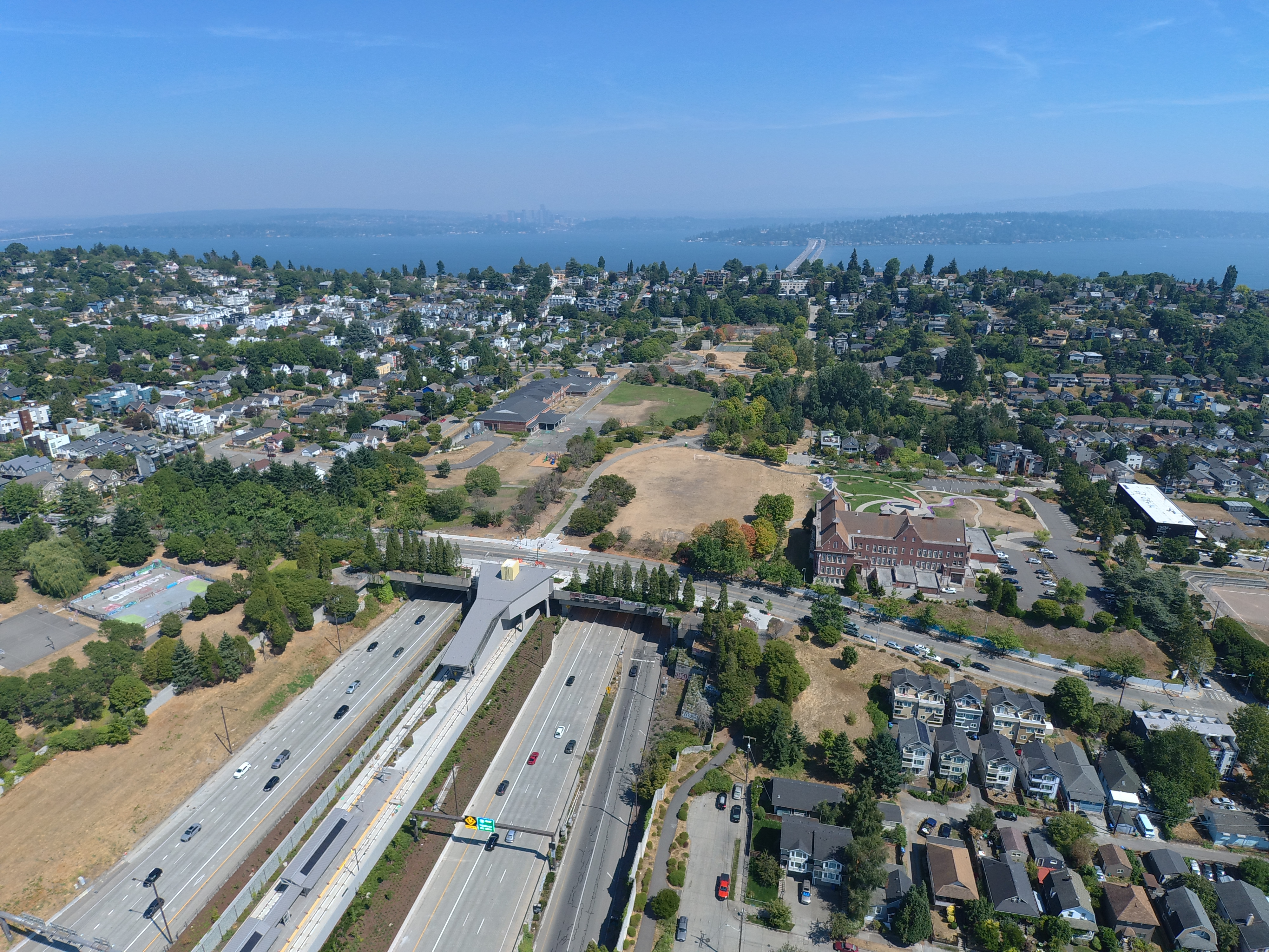
Catalyzed by the new harms of Interstate 5, today many parts of Seattle enjoy a strong urban fabric, quality parks, and quiet residential streets. This was clearly an equitable outcome for the Central Area and Mount Baker residents who were more likely to be lower-income and people of color than the rest of the city. This legacy of early citizen freeway activists could be reflected in the campaign for lidding I-5 in Downtown and other neighborhoods.
Limitations
The social benefits of lidding freeways has some limitations. Reduced exposure to noise and air pollution are localized to within a few blocks of a lid, and areas along uncovered portions of the corridor remain divided and adversely impacted.
Interstate 5 runs north-south through all 20 miles of Seattle. Its entirety cannot be lidded because the city’s topography provides a limited number of opportunities. Lids work where a freeway is in a trench with retaining walls or sloping embankments on both sides (or sometimes on only one side). Freeways running on flat ground or elevated on columns present altogether different challenges to mitigation, and so require alternative solutions.
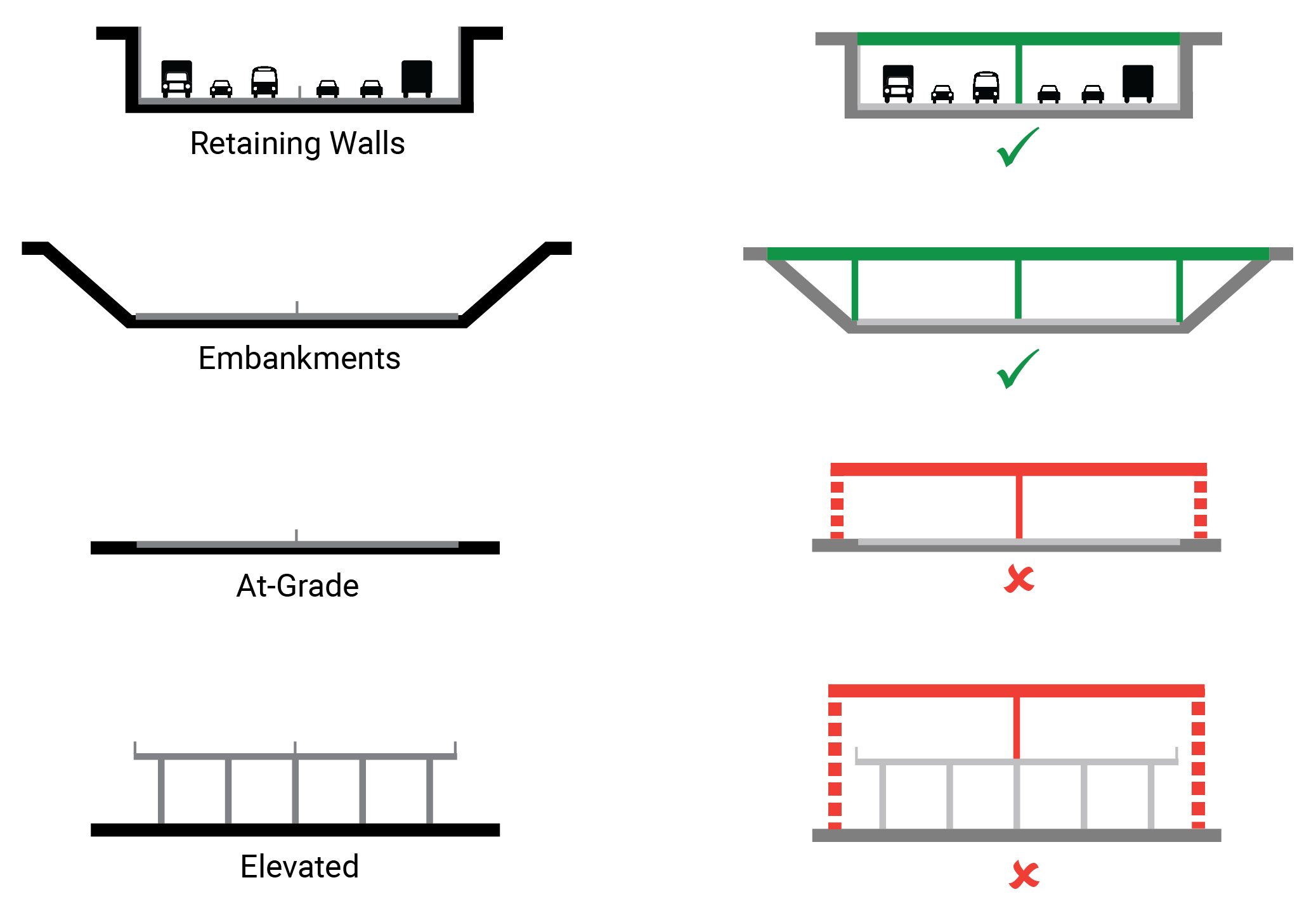
Seattle’s hilly terrain forced Interstate 5 to take all of these forms in close proximity. As a result, for example, ideal lid sites around Downtown are a stone’s throw from the towering viaducts above the International District-Chinatown and Eastlake. A potential long-term solution would be relocating elevated portions of I-5 underground. While this would be an expensive and complex endeavor, the locations selected for more intensive interventions could be prioritized using an equity lens.
Funding Sources
Like in any city, revenue sources and expenses for construction and day-to-day operations are separate. Operational funds for critical government services and infrastructure like public safety, schools, street maintenance, social services, community center programming, and affordable housing subsidies are drawn from dedicated sources that are separate from capital project spending. As a capital project, lidding I-5 would not directly compete with operations funds.
Projects of this scale usually require multiple capital funding sources. Interstate 5 has multiple stakeholders involved. The City of Seattle manages Freeway Park and the street overpasses, King County owns land on both sides of I-5 south of Madison Street, the Convention Center has two freeway-spanning facilities, Washington State owns the actual freeway right-of-way and airspace, and the federal government must approve changes to the national interstate system. Sound Transit also owns land in the study area and the Port of Seattle has an interest in ensuring the freeway is operational for freight traffic.
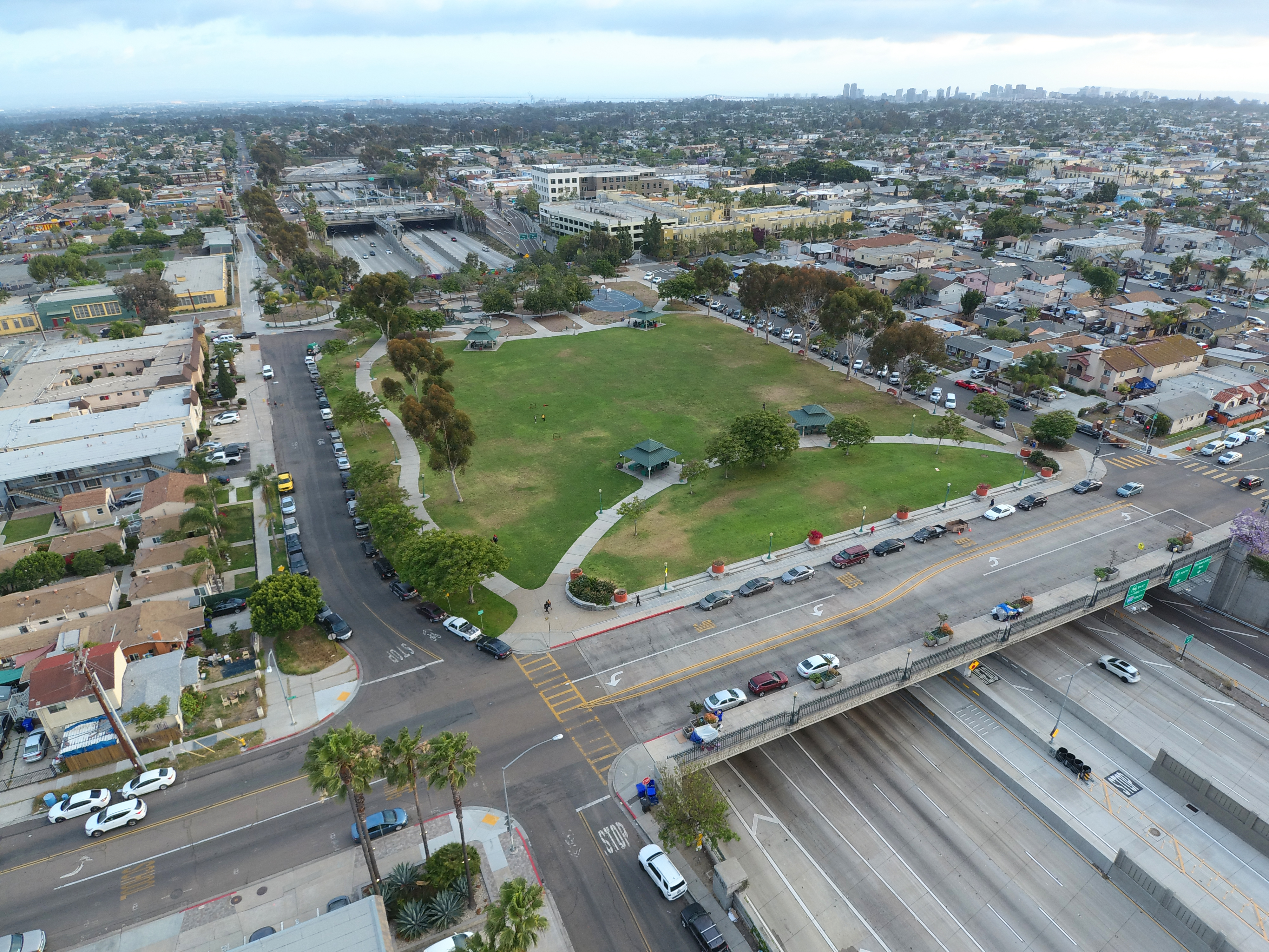
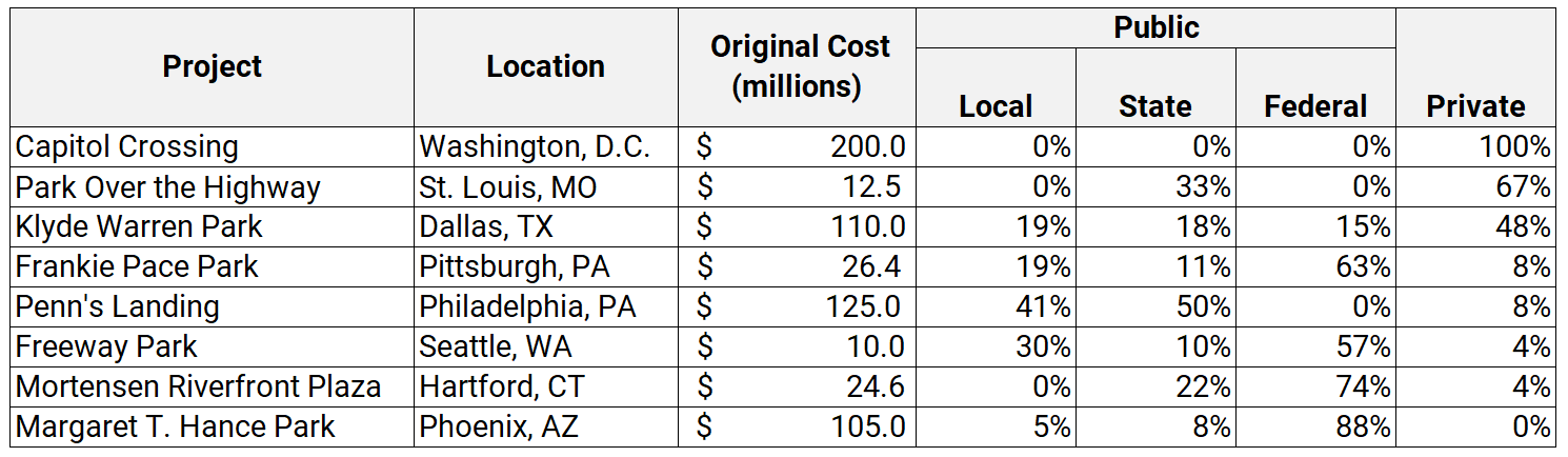
No single government entity or group of taxpayers will likely be called upon to fund the lid construction. Similar to Seattle’s new Waterfront Park, significant private involvement or philanthropy can also be expected with a city-building effort such as this, reducing the public obligation. These factors will help craft a fair funding strategy that spreads out the costs and benefits. Example funding mixes for several freeway lid projects are shown in the table below.
Public Participation
The Lid I-5 campaign has made it a mission to ensure future freeway lids are designed and planned with a bottom-up approach. The campaign is rare in its grassroots beginnings; many lid projects are initiated by government agencies or business interests. The campaign has not yet endorsed any particular design, and acts as a clearinghouse for ideas and information. To that end, the campaign has hosted a large number and variety of public outreach events since 2015. These events are nearly always free, open to the general public, and widely advertised. Informal surveys and anecdotal evidence suggests participation has been significant, enthusiastic, and diverse among gender, age, race, and socioeconomic background.
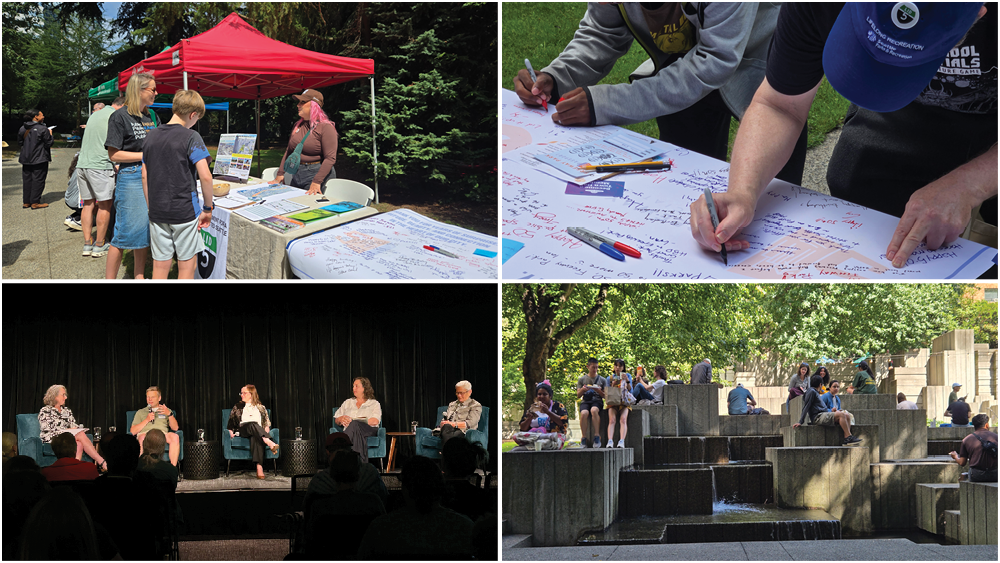
While Lid I-5 volunteers have received training and familiarity of the City of Seattle Racial and Social Justice Initiative (RSJI), it has not yet reached the broadest diversity of residents and community groups that it can. Campaign material and events may not be accessible to all. This is typical of a nascent volunteer-based advocacy organization with limited time and money.
Lid I-5 will continue to strive for a representative coalition and wide public participation. Prolonged and deep engagement with the most underrepresented and marginalized community members will be improved when a government agency or other formal entity sponsors the project. The sponsoring organization will have far greater resources and expertise than a volunteer group. As with all projects of this scale and longevity, the official work to fund, design, and build future lids will involve a major community engagement process. Established government agencies have the resources and expertise to best engage affected people in communities of color, low-income communities, immigrant communities, and other populations that are not traditionally well-versed in public policy, capital projects, and land use and transportation planning. Sponsorship is also essential to promote accessible engagement through translation services, visual and auditory disability accommodations, and childcare at events.
In the meantime, the volunteer Lid I-5 team will continue to broaden its outreach efforts, build a wide coalition of affected stakeholders, and always welcome ideas and participation by anyone.
Public Trust
Top-down, government-initiated projects run the risk of green-washing freeways and displacement risk. Such concerns came to pass with widening Interstate 70 in Denver, and are arising with plans to build lid parks in conjunction with widening Interstate 5 in Portland. In addition, as available land dwindles in Seattle’s Downtown and South Lake Union, private interests may inevitably look to the abundant freeway airspace as a development site. Commercial projects like Capitol Crossing in Washington, D.C. and Fenway Center in Boston offer some community benefit, but are primarily business-driven.
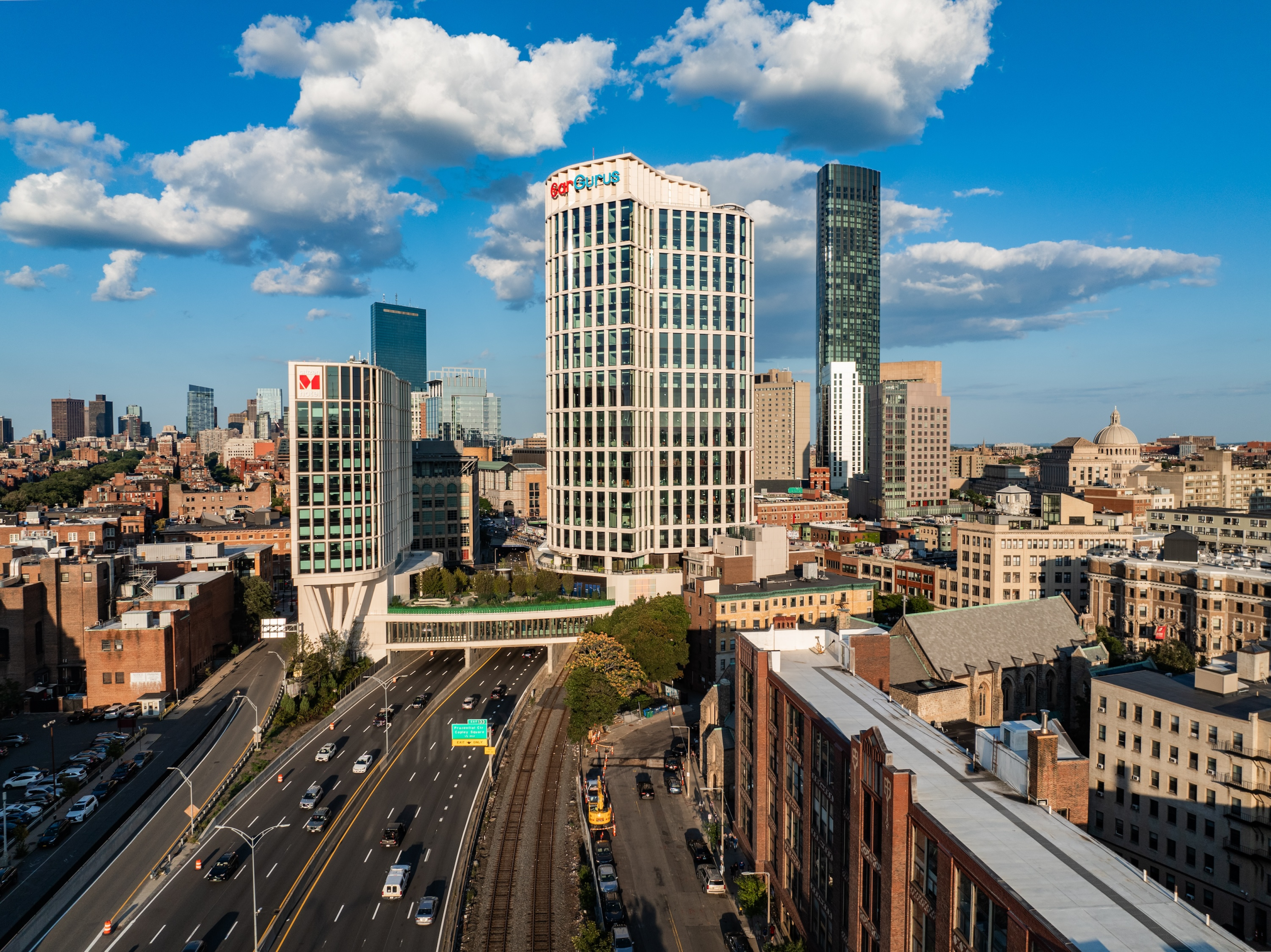
Projects like those demonstrate it is in the Seattle community’s best interest to proactively establish a vision and retain public control and ownership over the project, and ensure development rights remain in the public trust. Private players can and should have a role in real estate development on I-5 lids, but their priorities should not dominate when the community values an equitable, people-first approach to how the project is designed, funded, and governed. A community-based vision for the lid plan and design will be critical for equitable outcomes, which is precisely what the City’s next round of grant-funded work will do for the Downtown site.
Anti-Displacement Strategies
Major public works that improve quality-of-life can sometimes have the unintended consequence of economic displacement of nearby residents and small businesses. A new park or transit station are attractive amenities, and can promote higher property values that translate into higher property taxes for owners or higher rents for tenants. This is particularly a risk in high-cost cities where the real estate market is undersupplied and extremely competitive, like in Seattle.
The 2020 I-5 Lid Feasibility Study acknowledges this risk, and specific anti-displacement strategies will be developed with the City’s next round of grant-funded work for the Downtown site. Strategies to promote equity could include:
- Creating affordable housing on the lid, or converting some existing private buildings around the freeway into affordable housing. This is a promising opportunity with the new, well-funded Seattle Social Housing Public Development Authority, but could also involve partnerships with other public and nonprofit housing agencies. This would ensure more options for lower-income residents to stay in their neighborhoods.
- Applying Seattle’s community preference policy to any new market-rate or income-restricted affordable housing built on or near the lid. This would help people who are on the verge of being priced out of their home, or were previously, to live in the neighborhoods they have ties to.
- Using land value capture. This could involve tools like tax increment financing, which collect the increase in property taxes associated with an infrastructure project to help fund the project for a set amount of time. This ensures that the landowners who benefit most from the project also help pay directly for the project.
- Employ a diverse workforce. The City of Seattle has one of the most robust and comprehensive workforce development and economic opportunity programs in the nation, including a Women- and Minority-Owned Businesses Program that promotes equity in contracting with historically underutilized businesses.
- Designing and programming great public spaces. Public spaces on the lid itself should be designed as welcoming and accessible to everyone. Parks, plazas, street connections, and hillclimb assists should all be freely open to the public and have a variety of ways to use the spaces. This will help all Seattle residents, no matter how far away they live, feel pride and ownership in the project – similar to the successful model of Waterfront Park having a mix of seating, landscaping, play areas, restrooms, and other amenities for families and all other visitors. A well-funded maintenance and operations plan that promotes cleanliness, security, and year-round activity will also be essential.
Conclusion: Building Great Cities
Cities can be simply defined as lots of people living and doing things close together. The closer to the center of activity and opportunity, the more valuable that place is. The evidence suggests denser cities have higher wages, a greater number of patents and business opportunities, and reduced emissions from buildings and transportation. Therefore, the available land and airspace in successful cities is always at premium, and society has an interest in ensuring cities are well-functioning and enjoyable to live in.
Cars and the infrastructure they depend on are a massive challenge to this concept of the city. They isolate people from one another and deny spontaneous social contact and economic exchange that cities are built upon. In a dense city where land is limited, freeways and parking lots take up a disproportionate share of space compared to the number of people they transport. The death toll and environmental impacts of cars are also devastating on a global scale.
Lidding a freeway is a modest but meaningful compromise between these competing interests – creating more space for people to thrive in the city, while allowing the essential transportation function to continue. Readers compelled by this idea should visit www.lidi5.org and join the Lid I-5 campaign in its mission to build a more connected, sustainable, and equitable Seattle.