
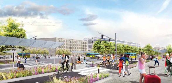
A vision of the future Seattle waterfront. (WSDOT)
The Alaskan Way Viaduct in downtown Seattle, a concrete double-decker relic of the 1950s highway boom, was slated for removal after damage from the 2001 Nisqually earthquake. The WSDOT, in partnership with the City of Seattle, Port of Seattle, and other agencies, demolished the southern half of the structure in 2011, and in July the the world’s largest boring machine started work on a 2 mile, $4.25 billion tunnel to replace this portion of state Highway 99. With the rest of the viaduct coming down in 2016, Waterfront Seattle, a partnership between the city and community, is leading the opportunity to reinvent the downtown shoreline. While the waterfront plan exhibits new attractions and a pedestrian focus, much of the vision is still dedicated to vehicle traffic.
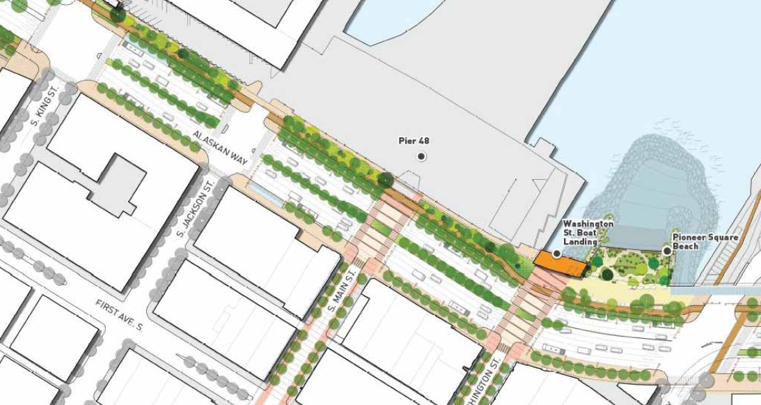
Street design from King Street to Yesler Way. (Waterfront Seattle)

Washington Street intersection vision. (Waterfront Seattle)
Right now Alaskan Way is a maze of ferry queue lanes, bus lanes, construction closures, pedestrian crossings, and under-viaduct parking and travel lanes. As an area frequented by tourists and residents alike, it is critical that the waterfront have cohesive transportation connections. Prepared by consulting firm Parametrix, a Street and Transit Update illustrates that this will be attempted through a 100+ feet wide street with up to nine traffic lanes.
Columbia Street intersection vision. (Waterfront Seattle)
The report does have cheery visuals, some provided by James Corner Field Operations of New York Highline fame, of a wide pedestrian promenade, dedicated bicycle path, plentiful vegetation, beach access, water features, etc., but from the business district these will only be reachable by crossing many lanes of traffic. In most rebuilt sections of Alaskan Way, there will be at least two general traffic lanes and a dedicated bus lane in each direction, along with loading and parking lanes. This size of street is redundant, as there will be a new north-south highway tunnel directly below these traffic lanes; a guest post on The Stranger iterates this point in dramatic fashion. The noise could even rival that of the viaduct, which is noticeable from blocks away. In the design’s defense, the wide streets are apparently only intended between King St. and Pine. St., with the rest of Alaskan Way not being heavily modified. But this stretch is one of the busiest and most popular areas on the waterfront.
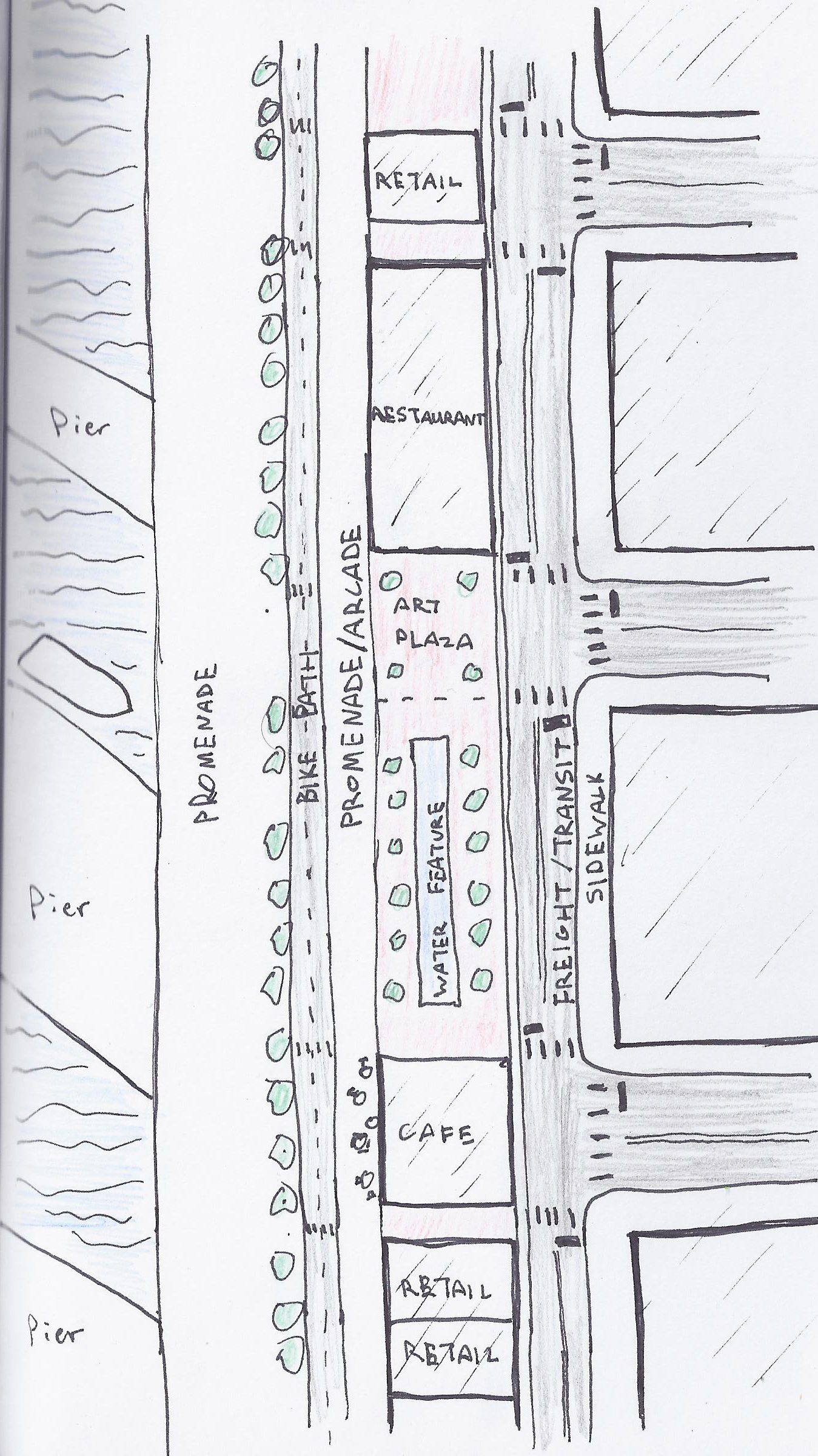
Quick sketch of street design alternative.
There are many alternatives. One, sketched at right, could take advantage of the existing need for freight routes to waterfront businesses, which would at most only require one lane in each direction; these lanes would be off-limits to private cars and host a rapid bus or streetcar line, both of which are considered in the report. This smaller road would be on the eastern edge of the proposed route, and between it and the bike path would be ample space for low-rise commercial development. Such a location could attract shops, cafes, restaurants, offices, and other businesses that would cater to waterfront visitors and spur further economic vibrancy. Another possibility is making the open space into a long park, outdoor public art gallery, or even a linear pond for aesthetic and recreational purposes.
However, emergency, delivery, and utility vehicle access would still need to be taken into account. Through points could be established at intervals.
The argument against these ideas is ferry traffic; Waterfront Seattle defends the street width with WSDOT’s authority to ensure adequate traffic flow to and from Colman Dock. The idea is to have one or two ferry queuing lanes south of the dock, but because Pier 52 already has large vehicle waiting areas these lanes would only be needed for peak summer sailings. If the alternative is considered and the lanes are actually necessary, they could be located opposite the shoreline with the freight/transit lanes to lessen noise, visual, and fume impacts on pedestrians.
A waterfront promenade that is separated from vehicle traffic, both physically and visually, would make for a much more pleasant pedestrian experience. Removing the distraction of loud and fast-moving cars will help direct attention to attractions on the shore side, likely improving both comfort and safety while improving the visibility of business and ecological features. Waterfront Seattle is commendable for its goal to revitalize one of the city’s main attributes, but in the important area of street design it has not gone far enough to plan an inviting pedestrian destination.
For more information on the projects, visit the Waterfront Seattle site or the WSDOT tunnel project page

Did anyone ever question if WSDOT could just start taking reservations for peak season sails? So then they wouldn’t need so much loading space. Like the Canadian system. Agree that the street design is on steroids. Disappointing.
Pingback: Emerald City Impressions: Explorations | The Northwest Urbanist
As a kid car camping with my family circa 1959 we traveled on this elevated road looking at the backs of ugly red buildings at a city on a waterfront. Other than port access keep auto access/travel to a minimum. Enough said.
Pingback: Plans, Plans, Plans: The Visions for Seattle’s Future | The Northwest Urbanist
Pingback: The Vision for Seattle’s Waterfront | The Northwest Urbanist
Simply desire to say your article is as surprising.
The clarity in your post is just nice and i could assume you’re an expert
on this subject. Well with your permission let me to grab your feed to keep updated
with forthcoming post. Thanks a million and please
keep up the enjoyable work.
Pingback: The Alaskan Way Viaduct Must Come Down | The Northwest Urbanist
Pingback: The Alaskan Way Viaduct Must Come Down, Not Be Converted Into a Park, Part 2 | The Urbanist
Pingback: Waterfront Design Predictably Disappoints Seattle – The Urbanist